You are here: Home > Network List > IW - Intermountain West Stations List
> Station MOOW Moose Ponds, Wyoming, USA > Earthquake Result Viewer
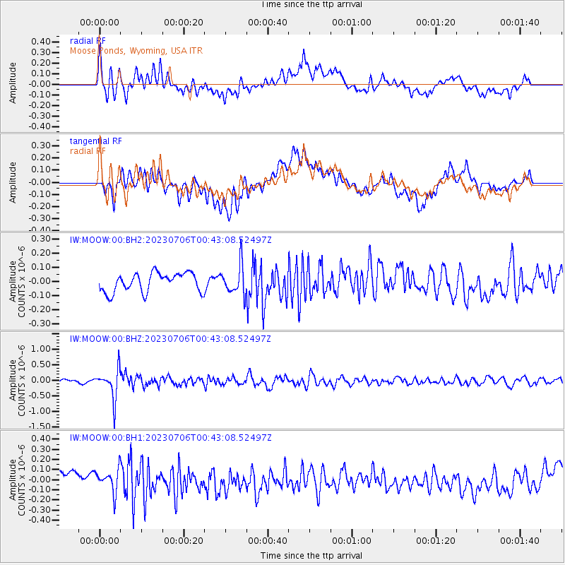
MOOW Moose Ponds, Wyoming, USA - Earthquake Result Viewer
*The percent match for this event was below the threshold and hence no stack was calculated.
| Earthquake location: |
Chile-Argentina Border Region |
| Earthquake latitude/longitude: |
-23.9/-67.9 |
| Earthquake time(UTC): |
2023/07/06 (187) 00:31:55 GMT |
| Earthquake Depth: |
132 km |
| Earthquake Magnitude: |
5.8 mww |
| Earthquake Catalog/Contributor: |
NEIC PDE/us |
|
| Network: |
IW Intermountain West |
| Station: |
MOOW Moose Ponds, Wyoming, USA |
| Lat/Lon: |
43.75 N/110.74 W |
| Elevation: |
2128 m |
|
| Distance: |
78.0 deg |
| Az: |
329.749 deg |
| Baz: |
140.496 deg |
| Ray Param: |
$rayparam |
*The percent match for this event was below the threshold and hence was not used in the summary stack. |
|
| Radial Match: |
60.718903 % |
| Radial Bump: |
400 |
| Transverse Match: |
40.068424 % |
| Transverse Bump: |
400 |
| SOD ConfigId: |
30536071 |
| Insert Time: |
2023-07-20 00:45:48.461 +0000 |
| GWidth: |
2.5 |
| Max Bumps: |
400 |
| Tol: |
0.001 |
|
Signal To Noise
| Channel | StoN | STA | LTA |
| IW:MOOW:00:BHZ:20230706T00:43:08.52497Z | 10.419749 | 4.81595E-7 | 4.621944E-8 |
| IW:MOOW:00:BH1:20230706T00:43:08.52497Z | 1.6987647 | 1.1441845E-7 | 6.7353916E-8 |
| IW:MOOW:00:BH2:20230706T00:43:08.52497Z | 1.571189 | 1.0637839E-7 | 6.7705656E-8 |
| Arrivals |
| Ps | |
| PpPs | |
| PsPs/PpSs | |


