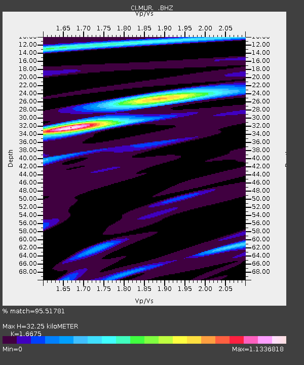
MUR Murrieta - Earthquake Result Viewer
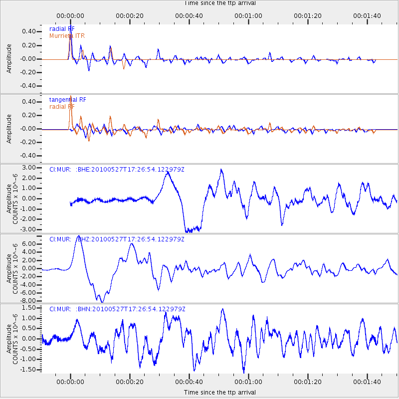
Earthquake location: Vanuatu Islands
Earthquake latitude/longitude: -13.7/166.6
Earthquake time(UTC): 2010/05/27 (147) 17:14:46 GMT
Earthquake Depth: 31 km
Earthquake Magnitude: 6.2 MB, 7.1 MS, 7.1 MW, 7.0 MW
Earthquake Catalog/Contributor: WHDF/NEIC
Network: CI Caltech Regional Seismic Network
Station: MUR Murrieta
Lat/Lon: 33.60 N/117.20 W
Elevation: 562 m
Distance: 86.3 deg
Az: 54.301 deg
Baz: 251.027 deg
Ray Param: 0.044107005
Estimated Moho Depth: 32.25 km
Estimated Crust Vp/Vs: 1.67
Assumed Crust Vp: 6.264 km/s
Estimated Crust Vs: 3.756 km/s
Estimated Crust Poisson's Ratio: 0.22
Radial Match: 95.51781 %
Radial Bump: 373
Transverse Match: 86.677124 %
Transverse Bump: 400
SOD ConfigId: 314592
Insert Time: 2010-09-14 07:27:56.991 +0000
GWidth: 2.5
Max Bumps: 400
Tol: 0.001

Signal To Noise

ChannelStoNSTALTA
CI:MUR: :BHZ:20100527T17:26:54.122979Z53.988135.225315E-69.678637E-8
CI:MUR: :BHN:20100527T17:26:54.122979Z2.1850115.009276E-72.2925636E-7
CI:MUR: :BHE:20100527T17:26:54.122979Z12.064861.813662E-61.5032599E-7
Arrivals
Ps3.5 SECOND
PpPs13 SECOND
PsPs/PpSs17 SECOND