You are here: Home > Network List > G - GEOSCOPE Stations List
> Station KIP Kipapa - Hawaii, USA > Earthquake Result Viewer
KIP Kipapa - Hawaii, USA - Earthquake Result Viewer
| Earthquake location: |
Vanuatu Islands |
| Earthquake latitude/longitude: |
-13.7/166.6 |
| Earthquake time(UTC): |
2010/05/27 (147) 17:14:46 GMT |
| Earthquake Depth: |
31 km |
| Earthquake Magnitude: |
6.2 MB, 7.1 MS, 7.1 MW, 7.0 MW |
| Earthquake Catalog/Contributor: |
WHDF/NEIC |
|
| Network: |
G GEOSCOPE |
| Station: |
KIP Kipapa - Hawaii, USA |
| Lat/Lon: |
21.42 N/158.01 W |
| Elevation: |
70 m |
|
| Distance: |
49.2 deg |
| Az: |
45.385 deg |
| Baz: |
227.948 deg |
| Ray Param: |
0.06878637 |
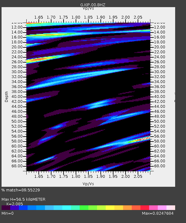
| Estimated Moho Depth: |
56.5 km |
| Estimated Crust Vp/Vs: |
2.09 |
| Assumed Crust Vp: |
4.24 km/s |
| Estimated Crust Vs: |
2.034 km/s |
| Estimated Crust Poisson's Ratio: |
0.35 |
|
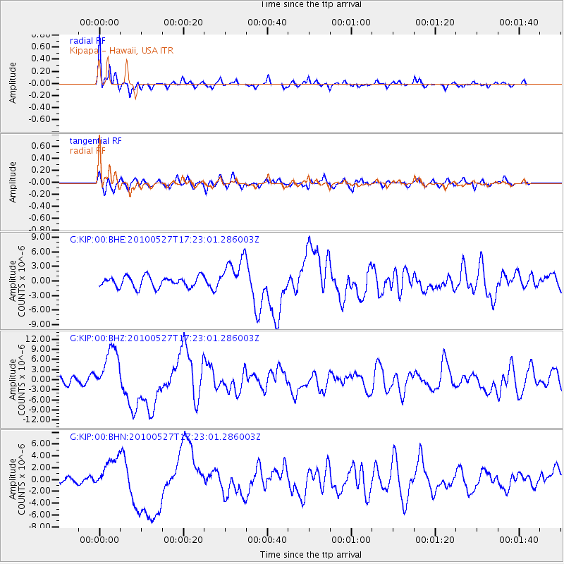
| Radial Match: |
89.55229 % |
| Radial Bump: |
350 |
| Transverse Match: |
71.13217 % |
| Transverse Bump: |
400 |
| SOD ConfigId: |
314592 |
| Insert Time: |
2010-09-14 07:28:24.426 +0000 |
| GWidth: |
2.5 |
| Max Bumps: |
400 |
| Tol: |
0.001 |
|
Signal To Noise
| Channel | StoN | STA | LTA |
| G:KIP:00:BHZ:20100527T17:23:01.286003Z | 3.9640276 | 6.9715666E-6 | 1.7587079E-6 |
| G:KIP:00:BHN:20100527T17:23:01.286003Z | 2.5526984 | 2.7921858E-6 | 1.0938173E-6 |
| G:KIP:00:BHE:20100527T17:23:01.286003Z | 3.3030283 | 3.6532692E-6 | 1.1060363E-6 |
| Arrivals |
| Ps | 15 SECOND |
| PpPs | 40 SECOND |
| PsPs/PpSs | 55 SECOND |


