You are here: Home > Network List > N4 - Central and EAstern US Network Stations List
> Station Y57A Sumter, SC, USA > Earthquake Result Viewer
Y57A Sumter, SC, USA - Earthquake Result Viewer
| Earthquake location: |
Chile-Argentina Border Region |
| Earthquake latitude/longitude: |
-23.9/-67.9 |
| Earthquake time(UTC): |
2023/07/06 (187) 00:31:55 GMT |
| Earthquake Depth: |
132 km |
| Earthquake Magnitude: |
5.8 mww |
| Earthquake Catalog/Contributor: |
NEIC PDE/us |
|
| Network: |
N4 Central and EAstern US Network |
| Station: |
Y57A Sumter, SC, USA |
| Lat/Lon: |
34.02 N/80.39 W |
| Elevation: |
56 m |
|
| Distance: |
58.8 deg |
| Az: |
347.887 deg |
| Baz: |
166.634 deg |
| Ray Param: |
0.062185556 |
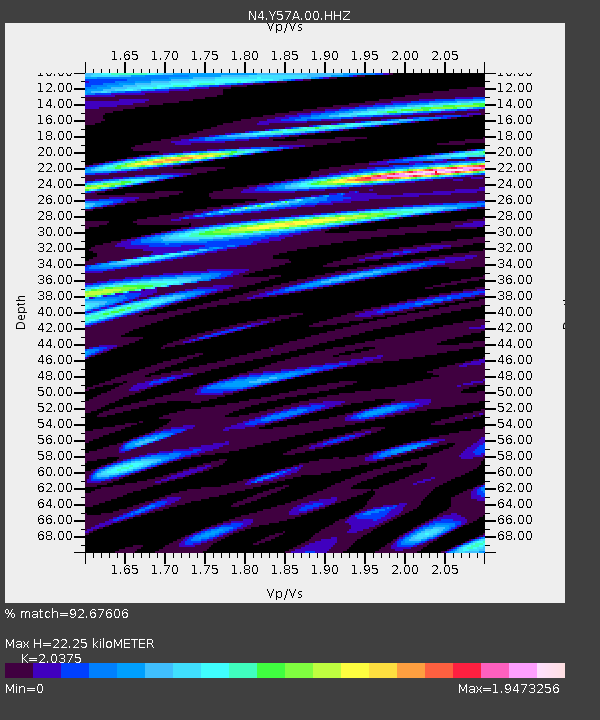
| Estimated Moho Depth: |
22.25 km |
| Estimated Crust Vp/Vs: |
2.04 |
| Assumed Crust Vp: |
6.419 km/s |
| Estimated Crust Vs: |
3.151 km/s |
| Estimated Crust Poisson's Ratio: |
0.34 |
|
| Radial Match: |
92.67606 % |
| Radial Bump: |
400 |
| Transverse Match: |
76.63192 % |
| Transverse Bump: |
400 |
| SOD ConfigId: |
30536071 |
| Insert Time: |
2023-07-20 00:50:30.671 +0000 |
| GWidth: |
2.5 |
| Max Bumps: |
400 |
| Tol: |
0.001 |
|

Signal To Noise
| Channel | StoN | STA | LTA |
| N4:Y57A:00:HHZ:20230706T00:41:09.859015Z | 13.835029 | 9.0123785E-7 | 6.514174E-8 |
| N4:Y57A:00:HH1:20230706T00:41:09.859015Z | 13.169179 | 1.5044567E-6 | 1.1424073E-7 |
| N4:Y57A:00:HH2:20230706T00:41:09.859015Z | 4.269864 | 4.299076E-7 | 1.0068415E-7 |
| Arrivals |
| Ps | 3.7 SECOND |
| PpPs | 10 SECOND |
| PsPs/PpSs | 14 SECOND |


