You are here: Home > Network List > O2 - Oklahoma Consolidated Temporary Seismic Networks Stations List
> Station PW10 Pawnee, Oklahoma > Earthquake Result Viewer
PW10 Pawnee, Oklahoma - Earthquake Result Viewer
| Earthquake location: |
Chile-Argentina Border Region |
| Earthquake latitude/longitude: |
-23.9/-67.9 |
| Earthquake time(UTC): |
2023/07/06 (187) 00:31:55 GMT |
| Earthquake Depth: |
132 km |
| Earthquake Magnitude: |
5.8 mww |
| Earthquake Catalog/Contributor: |
NEIC PDE/us |
|
| Network: |
O2 Oklahoma Consolidated Temporary Seismic Networks |
| Station: |
PW10 Pawnee, Oklahoma |
| Lat/Lon: |
36.37 N/96.83 W |
| Elevation: |
297 m |
|
| Distance: |
65.9 deg |
| Az: |
334.681 deg |
| Baz: |
150.998 deg |
| Ray Param: |
0.057608306 |
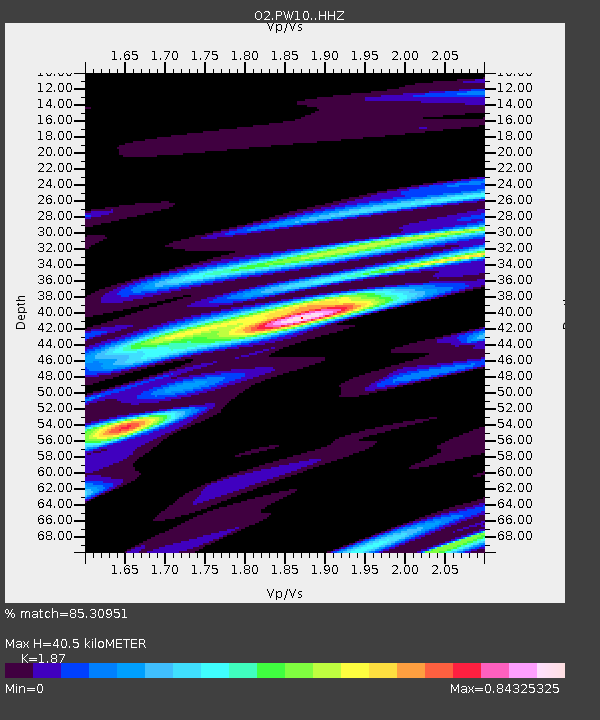
| Estimated Moho Depth: |
40.5 km |
| Estimated Crust Vp/Vs: |
1.87 |
| Assumed Crust Vp: |
6.483 km/s |
| Estimated Crust Vs: |
3.467 km/s |
| Estimated Crust Poisson's Ratio: |
0.30 |
|
| Radial Match: |
85.30951 % |
| Radial Bump: |
400 |
| Transverse Match: |
66.70616 % |
| Transverse Bump: |
400 |
| SOD ConfigId: |
30536071 |
| Insert Time: |
2023-07-20 00:53:43.319 +0000 |
| GWidth: |
2.5 |
| Max Bumps: |
400 |
| Tol: |
0.001 |
|

Signal To Noise
| Channel | StoN | STA | LTA |
| O2:PW10: :HHZ:20230706T00:41:56.724982Z | 12.19119 | 9.790185E-7 | 8.030541E-8 |
| O2:PW10: :HHN:20230706T00:41:56.724982Z | 4.4431295 | 2.9268028E-7 | 6.587255E-8 |
| O2:PW10: :HHE:20230706T00:41:56.724982Z | 3.675546 | 3.121457E-7 | 8.4924984E-8 |
| Arrivals |
| Ps | 5.7 SECOND |
| PpPs | 17 SECOND |
| PsPs/PpSs | 23 SECOND |


