You are here: Home > Network List > TX - Texas Seismological Network Stations List
> Station PB28 Culberson South > Earthquake Result Viewer
PB28 Culberson South - Earthquake Result Viewer
| Earthquake location: |
Chile-Argentina Border Region |
| Earthquake latitude/longitude: |
-23.9/-67.9 |
| Earthquake time(UTC): |
2023/07/06 (187) 00:31:55 GMT |
| Earthquake Depth: |
132 km |
| Earthquake Magnitude: |
5.8 mww |
| Earthquake Catalog/Contributor: |
NEIC PDE/us |
|
| Network: |
TX Texas Seismological Network |
| Station: |
PB28 Culberson South |
| Lat/Lon: |
31.67 N/104.50 W |
| Elevation: |
1204 m |
|
| Distance: |
65.4 deg |
| Az: |
326.021 deg |
| Baz: |
143.145 deg |
| Ray Param: |
0.057910595 |
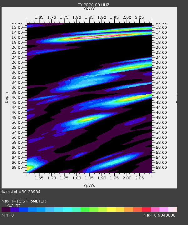
| Estimated Moho Depth: |
15.5 km |
| Estimated Crust Vp/Vs: |
1.87 |
| Assumed Crust Vp: |
6.361 km/s |
| Estimated Crust Vs: |
3.401 km/s |
| Estimated Crust Poisson's Ratio: |
0.30 |
|
| Radial Match: |
89.33984 % |
| Radial Bump: |
389 |
| Transverse Match: |
76.95412 % |
| Transverse Bump: |
400 |
| SOD ConfigId: |
30536071 |
| Insert Time: |
2023-07-20 01:00:01.894 +0000 |
| GWidth: |
2.5 |
| Max Bumps: |
400 |
| Tol: |
0.001 |
|

Signal To Noise
| Channel | StoN | STA | LTA |
| TX:PB28:00:HHZ:20230706T00:41:53.760016Z | 18.218187 | 9.619081E-7 | 5.2799326E-8 |
| TX:PB28:00:HH1:20230706T00:41:53.760016Z | 6.6752024 | 2.1160022E-7 | 3.1699447E-8 |
| TX:PB28:00:HH2:20230706T00:41:53.760016Z | 6.566363 | 1.5165662E-7 | 2.3095986E-8 |
| Arrivals |
| Ps | 2.2 SECOND |
| PpPs | 6.7 SECOND |
| PsPs/PpSs | 8.9 SECOND |


