You are here: Home > Network List > US - United States National Seismic Network Stations List
> Station HAWA Hanford, Washington, USA > Earthquake Result Viewer
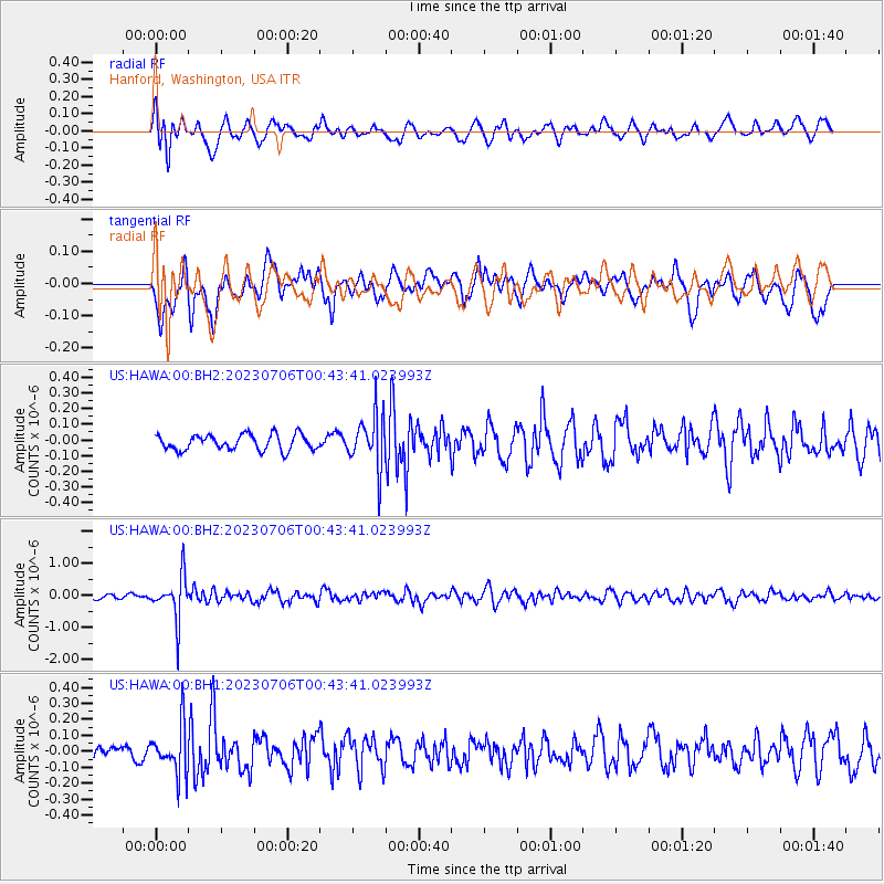
HAWA Hanford, Washington, USA - Earthquake Result Viewer
*The percent match for this event was below the threshold and hence no stack was calculated.
| Earthquake location: |
Chile-Argentina Border Region |
| Earthquake latitude/longitude: |
-23.9/-67.9 |
| Earthquake time(UTC): |
2023/07/06 (187) 00:31:55 GMT |
| Earthquake Depth: |
132 km |
| Earthquake Magnitude: |
5.8 mww |
| Earthquake Catalog/Contributor: |
NEIC PDE/us |
|
| Network: |
US United States National Seismic Network |
| Station: |
HAWA Hanford, Washington, USA |
| Lat/Lon: |
46.39 N/119.53 W |
| Elevation: |
364 m |
|
| Distance: |
84.1 deg |
| Az: |
326.944 deg |
| Baz: |
133.85 deg |
| Ray Param: |
$rayparam |
*The percent match for this event was below the threshold and hence was not used in the summary stack. |
|
| Radial Match: |
58.9633 % |
| Radial Bump: |
400 |
| Transverse Match: |
52.112514 % |
| Transverse Bump: |
400 |
| SOD ConfigId: |
30536071 |
| Insert Time: |
2023-07-20 01:02:17.163 +0000 |
| GWidth: |
2.5 |
| Max Bumps: |
400 |
| Tol: |
0.001 |
|
Signal To Noise
| Channel | StoN | STA | LTA |
| US:HAWA:00:BHZ:20230706T00:43:41.023993Z | 5.6482286 | 6.841272E-7 | 1.2112244E-7 |
| US:HAWA:00:BH1:20230706T00:43:41.023993Z | 1.7915264 | 1.5238265E-7 | 8.5057444E-8 |
| US:HAWA:00:BH2:20230706T00:43:41.023993Z | 3.3567576 | 1.6702234E-7 | 4.9757045E-8 |
| Arrivals |
| Ps | |
| PpPs | |
| PsPs/PpSs | |


