You are here: Home > Network List > UU - University of Utah Regional Network Stations List
> Station SVWY Solvay Mine, WY, USA > Earthquake Result Viewer
SVWY Solvay Mine, WY, USA - Earthquake Result Viewer
| Earthquake location: |
Solomon Islands |
| Earthquake latitude/longitude: |
-10.5/163.1 |
| Earthquake time(UTC): |
2018/11/16 (320) 03:26:55 GMT |
| Earthquake Depth: |
11 km |
| Earthquake Magnitude: |
6.2 mww |
| Earthquake Catalog/Contributor: |
NEIC PDE/us |
|
| Network: |
UU University of Utah Regional Network |
| Station: |
SVWY Solvay Mine, WY, USA |
| Lat/Lon: |
41.45 N/109.86 W |
| Elevation: |
1950 m |
|
| Distance: |
94.7 deg |
| Az: |
48.867 deg |
| Baz: |
260.162 deg |
| Ray Param: |
0.040990602 |
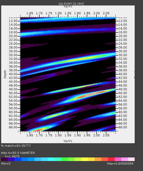
| Estimated Moho Depth: |
50.5 km |
| Estimated Crust Vp/Vs: |
1.97 |
| Assumed Crust Vp: |
6.207 km/s |
| Estimated Crust Vs: |
3.155 km/s |
| Estimated Crust Poisson's Ratio: |
0.33 |
|
| Radial Match: |
83.35777 % |
| Radial Bump: |
286 |
| Transverse Match: |
56.64695 % |
| Transverse Bump: |
377 |
| SOD ConfigId: |
3165032 |
| Insert Time: |
2018-11-30 03:35:44.145 +0000 |
| GWidth: |
2.5 |
| Max Bumps: |
400 |
| Tol: |
0.001 |
|

Signal To Noise
| Channel | StoN | STA | LTA |
| UU:SVWY:01:HHZ:20181116T03:39:44.639021Z | 1.5636156 | 3.9868898E-8 | 2.5497888E-8 |
| UU:SVWY:01:HHN:20181116T03:39:44.639021Z | 1.153766 | 2.3380634E-8 | 2.0264624E-8 |
| UU:SVWY:01:HHE:20181116T03:39:44.639021Z | 2.2556818 | 1.9875438E-8 | 8.811277E-9 |
| Arrivals |
| Ps | 8.0 SECOND |
| PpPs | 24 SECOND |
| PsPs/PpSs | 32 SECOND |


