You are here: Home > Network List > TA - USArray Transportable Network (new EarthScope stations) Stations List
> Station I20A Worland, WY, USA > Earthquake Result Viewer
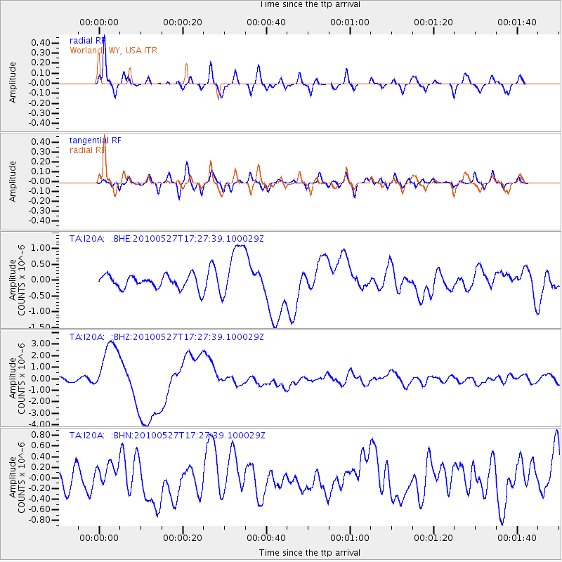
I20A Worland, WY, USA - Earthquake Result Viewer
*The percent match for this event was below the threshold and hence no stack was calculated.
| Earthquake location: |
Vanuatu Islands |
| Earthquake latitude/longitude: |
-13.7/166.6 |
| Earthquake time(UTC): |
2010/05/27 (147) 17:14:46 GMT |
| Earthquake Depth: |
31 km |
| Earthquake Magnitude: |
6.2 MB, 7.1 MS, 7.1 MW, 7.0 MW |
| Earthquake Catalog/Contributor: |
WHDF/NEIC |
|
| Network: |
TA USArray Transportable Network (new EarthScope stations) |
| Station: |
I20A Worland, WY, USA |
| Lat/Lon: |
43.95 N/108.13 W |
| Elevation: |
1342 m |
|
| Distance: |
96.0 deg |
| Az: |
46.363 deg |
| Baz: |
256.873 deg |
| Ray Param: |
$rayparam |
*The percent match for this event was below the threshold and hence was not used in the summary stack. |
|
| Radial Match: |
84.83554 % |
| Radial Bump: |
400 |
| Transverse Match: |
60.46951 % |
| Transverse Bump: |
400 |
| SOD ConfigId: |
314592 |
| Insert Time: |
2010-09-14 07:36:06.599 +0000 |
| GWidth: |
2.5 |
| Max Bumps: |
400 |
| Tol: |
0.001 |
|
Signal To Noise
| Channel | StoN | STA | LTA |
| TA:I20A: :BHZ:20100527T17:27:39.100029Z | 15.589325 | 2.386149E-6 | 1.53063E-7 |
| TA:I20A: :BHN:20100527T17:27:39.100029Z | 0.94505984 | 2.2146243E-7 | 2.3433695E-7 |
| TA:I20A: :BHE:20100527T17:27:39.100029Z | 4.2425203 | 8.604549E-7 | 2.0281692E-7 |
| Arrivals |
| Ps | |
| PpPs | |
| PsPs/PpSs | |


