You are here: Home > Network List > TA - USArray Transportable Network (new EarthScope stations) Stations List
> Station H19A Powell, WY, USA > Earthquake Result Viewer
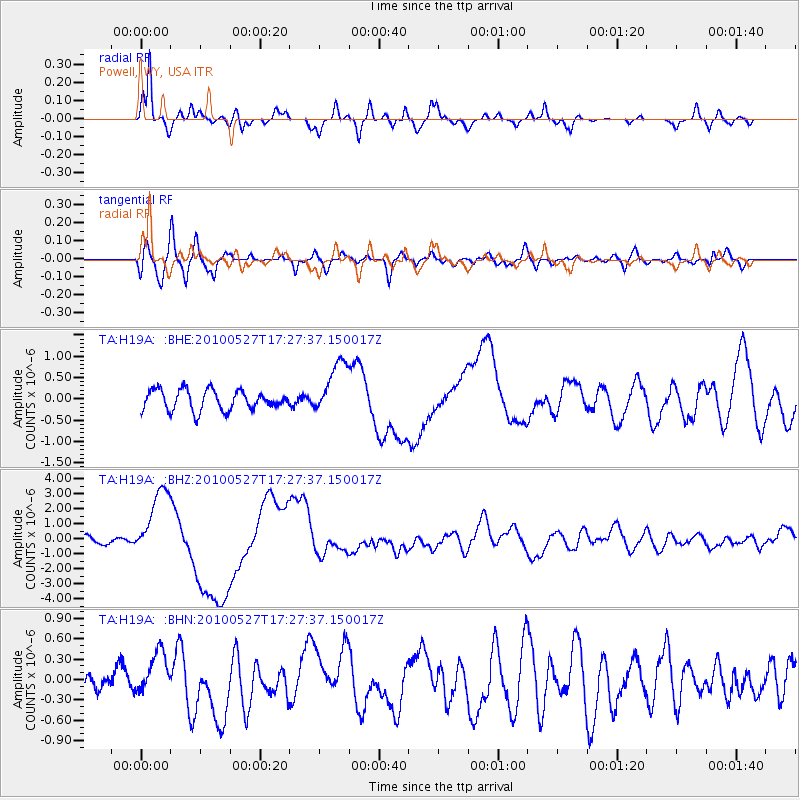
H19A Powell, WY, USA - Earthquake Result Viewer
*The percent match for this event was below the threshold and hence no stack was calculated.
| Earthquake location: |
Vanuatu Islands |
| Earthquake latitude/longitude: |
-13.7/166.6 |
| Earthquake time(UTC): |
2010/05/27 (147) 17:14:46 GMT |
| Earthquake Depth: |
31 km |
| Earthquake Magnitude: |
6.2 MB, 7.1 MS, 7.1 MW, 7.0 MW |
| Earthquake Catalog/Contributor: |
WHDF/NEIC |
|
| Network: |
TA USArray Transportable Network (new EarthScope stations) |
| Station: |
H19A Powell, WY, USA |
| Lat/Lon: |
44.67 N/108.99 W |
| Elevation: |
1479 m |
|
| Distance: |
95.6 deg |
| Az: |
45.515 deg |
| Baz: |
256.362 deg |
| Ray Param: |
$rayparam |
*The percent match for this event was below the threshold and hence was not used in the summary stack. |
|
| Radial Match: |
87.61342 % |
| Radial Bump: |
400 |
| Transverse Match: |
65.984024 % |
| Transverse Bump: |
400 |
| SOD ConfigId: |
314592 |
| Insert Time: |
2010-09-14 07:37:08.446 +0000 |
| GWidth: |
2.5 |
| Max Bumps: |
400 |
| Tol: |
0.001 |
|
Signal To Noise
| Channel | StoN | STA | LTA |
| TA:H19A: :BHZ:20100527T17:27:37.150017Z | 9.440269 | 2.3797588E-6 | 2.520859E-7 |
| TA:H19A: :BHN:20100527T17:27:37.150017Z | 1.9383429 | 3.1903366E-7 | 1.6459093E-7 |
| TA:H19A: :BHE:20100527T17:27:37.150017Z | 2.7214503 | 6.3493724E-7 | 2.3330843E-7 |
| Arrivals |
| Ps | |
| PpPs | |
| PsPs/PpSs | |


