You are here: Home > Network List > TA - USArray Transportable Network (new EarthScope stations) Stations List
> Station B19A Brinkman Farms, Chinook, MT, USA > Earthquake Result Viewer
B19A Brinkman Farms, Chinook, MT, USA - Earthquake Result Viewer
| Earthquake location: |
Vanuatu Islands |
| Earthquake latitude/longitude: |
-13.7/166.6 |
| Earthquake time(UTC): |
2010/05/27 (147) 17:14:46 GMT |
| Earthquake Depth: |
31 km |
| Earthquake Magnitude: |
6.2 MB, 7.1 MS, 7.1 MW, 7.0 MW |
| Earthquake Catalog/Contributor: |
WHDF/NEIC |
|
| Network: |
TA USArray Transportable Network (new EarthScope stations) |
| Station: |
B19A Brinkman Farms, Chinook, MT, USA |
| Lat/Lon: |
48.46 N/108.94 W |
| Elevation: |
803 m |
|
| Distance: |
96.5 deg |
| Az: |
41.819 deg |
| Baz: |
256.779 deg |
| Ray Param: |
0.040492892 |
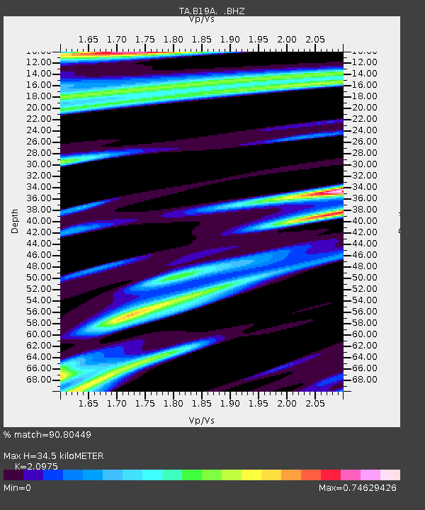
| Estimated Moho Depth: |
34.5 km |
| Estimated Crust Vp/Vs: |
2.10 |
| Assumed Crust Vp: |
6.438 km/s |
| Estimated Crust Vs: |
3.069 km/s |
| Estimated Crust Poisson's Ratio: |
0.35 |
|
| Radial Match: |
90.80449 % |
| Radial Bump: |
400 |
| Transverse Match: |
61.961998 % |
| Transverse Bump: |
400 |
| SOD ConfigId: |
314592 |
| Insert Time: |
2010-09-14 07:38:01.865 +0000 |
| GWidth: |
2.5 |
| Max Bumps: |
400 |
| Tol: |
0.001 |
|

Signal To Noise
| Channel | StoN | STA | LTA |
| TA:B19A: :BHZ:20100527T17:27:41.249993Z | 13.445062 | 2.3565321E-6 | 1.7527121E-7 |
| TA:B19A: :BHN:20100527T17:27:41.249993Z | 0.8402372 | 2.6096706E-7 | 3.1058738E-7 |
| TA:B19A: :BHE:20100527T17:27:41.249993Z | 3.6033049 | 8.10702E-7 | 2.2498845E-7 |
| Arrivals |
| Ps | 6.0 SECOND |
| PpPs | 16 SECOND |
| PsPs/PpSs | 22 SECOND |


