You are here: Home > Network List > GS - US Geological Survey Networks Stations List
> Station OK051 E0350 and S34600 Roads, Ralston, OK > Earthquake Result Viewer
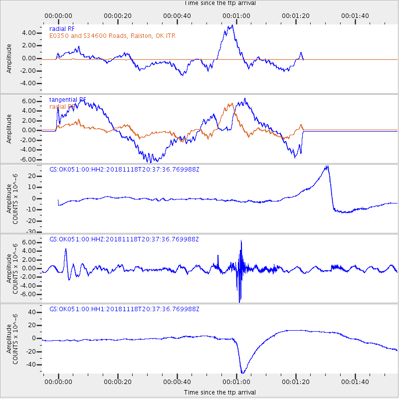
OK051 E0350 and S34600 Roads, Ralston, OK - Earthquake Result Viewer
*The percent match for this event was below the threshold and hence no stack was calculated.
| Earthquake location: |
Fiji Islands Region |
| Earthquake latitude/longitude: |
-17.9/-178.9 |
| Earthquake time(UTC): |
2018/11/18 (322) 20:25:45 GMT |
| Earthquake Depth: |
534 km |
| Earthquake Magnitude: |
6.7 Mww |
| Earthquake Catalog/Contributor: |
NEIC PDE/us |
|
| Network: |
GS US Geological Survey Networks |
| Station: |
OK051 E0350 and S34600 Roads, Ralston, OK |
| Lat/Lon: |
36.51 N/96.84 W |
| Elevation: |
263 m |
|
| Distance: |
94.3 deg |
| Az: |
53.153 deg |
| Baz: |
251.041 deg |
| Ray Param: |
$rayparam |
*The percent match for this event was below the threshold and hence was not used in the summary stack. |
|
| Radial Match: |
37.12883 % |
| Radial Bump: |
386 |
| Transverse Match: |
54.755756 % |
| Transverse Bump: |
400 |
| SOD ConfigId: |
3165032 |
| Insert Time: |
2018-12-02 20:33:27.098 +0000 |
| GWidth: |
2.5 |
| Max Bumps: |
400 |
| Tol: |
0.001 |
|
Signal To Noise
| Channel | StoN | STA | LTA |
| GS:OK051:00:HHZ:20181118T20:37:36.769988Z | 3.7909036 | 1.7367162E-6 | 4.5812723E-7 |
| GS:OK051:00:HH1:20181118T20:37:36.769988Z | 0.96380496 | 4.7775375E-6 | 4.9569544E-6 |
| GS:OK051:00:HH2:20181118T20:37:36.769988Z | 0.3521641 | 7.172618E-7 | 2.036726E-6 |
| Arrivals |
| Ps | |
| PpPs | |
| PsPs/PpSs | |


