You are here: Home > Network List > TA - USArray Transportable Network (new EarthScope stations) Stations List
> Station J23A Dilts Ranch, Bill, WY, USA > Earthquake Result Viewer
J23A Dilts Ranch, Bill, WY, USA - Earthquake Result Viewer
| Earthquake location: |
Vanuatu Islands |
| Earthquake latitude/longitude: |
-13.7/166.6 |
| Earthquake time(UTC): |
2010/05/27 (147) 17:14:46 GMT |
| Earthquake Depth: |
31 km |
| Earthquake Magnitude: |
6.2 MB, 7.1 MS, 7.1 MW, 7.0 MW |
| Earthquake Catalog/Contributor: |
WHDF/NEIC |
|
| Network: |
TA USArray Transportable Network (new EarthScope stations) |
| Station: |
J23A Dilts Ranch, Bill, WY, USA |
| Lat/Lon: |
43.40 N/105.55 W |
| Elevation: |
1499 m |
|
| Distance: |
97.7 deg |
| Az: |
47.301 deg |
| Baz: |
258.534 deg |
| Ray Param: |
0.04012073 |
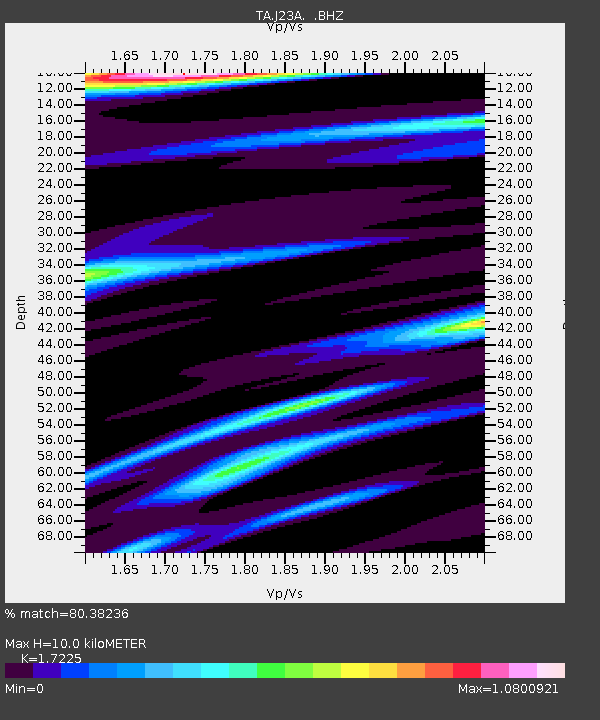
| Estimated Moho Depth: |
10.0 km |
| Estimated Crust Vp/Vs: |
1.72 |
| Assumed Crust Vp: |
6.159 km/s |
| Estimated Crust Vs: |
3.575 km/s |
| Estimated Crust Poisson's Ratio: |
0.25 |
|
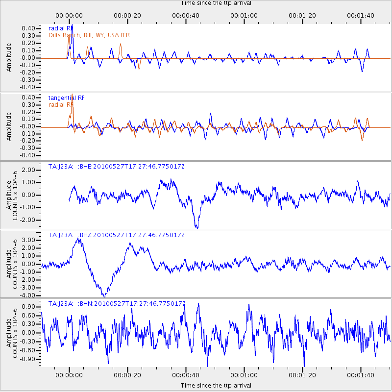
| Radial Match: |
80.38236 % |
| Radial Bump: |
400 |
| Transverse Match: |
54.057446 % |
| Transverse Bump: |
400 |
| SOD ConfigId: |
314592 |
| Insert Time: |
2010-09-14 07:38:53.487 +0000 |
| GWidth: |
2.5 |
| Max Bumps: |
400 |
| Tol: |
0.001 |
|
Signal To Noise
| Channel | StoN | STA | LTA |
| TA:J23A: :BHZ:20100527T17:27:46.775017Z | 9.702312 | 2.2501304E-6 | 2.3191691E-7 |
| TA:J23A: :BHN:20100527T17:27:46.775017Z | 0.8426688 | 3.744581E-7 | 4.4437164E-7 |
| TA:J23A: :BHE:20100527T17:27:46.775017Z | 2.660187 | 8.3182994E-7 | 3.1269605E-7 |
| Arrivals |
| Ps | 1.2 SECOND |
| PpPs | 4.3 SECOND |
| PsPs/PpSs | 5.5 SECOND |


