You are here: Home > Network List > TA - USArray Transportable Network (new EarthScope stations) Stations List
> Station V27A Dan Oppilter Farms, Dalhart, TX, USA > Earthquake Result Viewer
V27A Dan Oppilter Farms, Dalhart, TX, USA - Earthquake Result Viewer
| Earthquake location: |
Vanuatu Islands |
| Earthquake latitude/longitude: |
-13.7/166.6 |
| Earthquake time(UTC): |
2010/05/27 (147) 17:14:46 GMT |
| Earthquake Depth: |
31 km |
| Earthquake Magnitude: |
6.2 MB, 7.1 MS, 7.1 MW, 7.0 MW |
| Earthquake Catalog/Contributor: |
WHDF/NEIC |
|
| Network: |
TA USArray Transportable Network (new EarthScope stations) |
| Station: |
V27A Dan Oppilter Farms, Dalhart, TX, USA |
| Lat/Lon: |
35.76 N/102.84 W |
| Elevation: |
1228 m |
|
| Distance: |
98.3 deg |
| Az: |
55.276 deg |
| Baz: |
259.152 deg |
| Ray Param: |
0.039934844 |
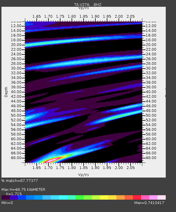
| Estimated Moho Depth: |
68.75 km |
| Estimated Crust Vp/Vs: |
1.72 |
| Assumed Crust Vp: |
6.242 km/s |
| Estimated Crust Vs: |
3.64 km/s |
| Estimated Crust Poisson's Ratio: |
0.24 |
|
| Radial Match: |
87.77377 % |
| Radial Bump: |
400 |
| Transverse Match: |
43.924824 % |
| Transverse Bump: |
400 |
| SOD ConfigId: |
314592 |
| Insert Time: |
2010-09-14 07:40:40.383 +0000 |
| GWidth: |
2.5 |
| Max Bumps: |
400 |
| Tol: |
0.001 |
|

Signal To Noise
| Channel | StoN | STA | LTA |
| TA:V27A: :BHZ:20100527T17:27:49.374993Z | 3.1886744 | 1.7591428E-6 | 5.5168465E-7 |
| TA:V27A: :BHN:20100527T17:27:49.374993Z | 0.6070375 | 5.062487E-7 | 8.3396606E-7 |
| TA:V27A: :BHE:20100527T17:27:49.374993Z | 1.6903319 | 7.491735E-7 | 4.432109E-7 |
| Arrivals |
| Ps | 8.0 SECOND |
| PpPs | 29 SECOND |
| PsPs/PpSs | 37 SECOND |


