You are here: Home > Network List > TA - USArray Transportable Network (new EarthScope stations) Stations List
> Station F04D Rainier, OR, USA > Earthquake Result Viewer
F04D Rainier, OR, USA - Earthquake Result Viewer
| Earthquake location: |
Vanuatu Islands |
| Earthquake latitude/longitude: |
-13.7/166.6 |
| Earthquake time(UTC): |
2010/05/27 (147) 17:14:46 GMT |
| Earthquake Depth: |
31 km |
| Earthquake Magnitude: |
6.2 MB, 7.1 MS, 7.1 MW, 7.0 MW |
| Earthquake Catalog/Contributor: |
WHDF/NEIC |
|
| Network: |
TA USArray Transportable Network (new EarthScope stations) |
| Station: |
F04D Rainier, OR, USA |
| Lat/Lon: |
46.08 N/123.01 W |
| Elevation: |
236 m |
|
| Distance: |
86.6 deg |
| Az: |
41.042 deg |
| Baz: |
246.473 deg |
| Ray Param: |
0.04386447 |
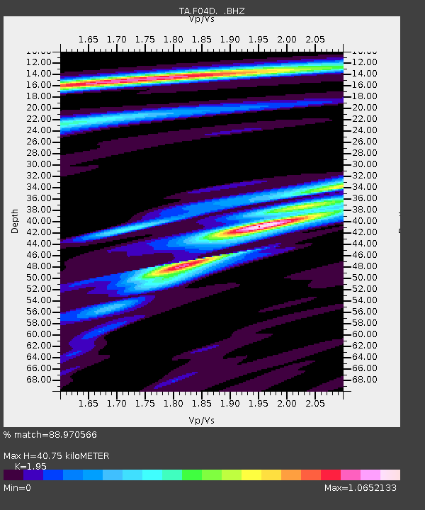
| Estimated Moho Depth: |
40.75 km |
| Estimated Crust Vp/Vs: |
1.95 |
| Assumed Crust Vp: |
6.566 km/s |
| Estimated Crust Vs: |
3.367 km/s |
| Estimated Crust Poisson's Ratio: |
0.32 |
|
| Radial Match: |
88.970566 % |
| Radial Bump: |
400 |
| Transverse Match: |
87.357605 % |
| Transverse Bump: |
400 |
| SOD ConfigId: |
314592 |
| Insert Time: |
2010-09-14 07:41:40.024 +0000 |
| GWidth: |
2.5 |
| Max Bumps: |
400 |
| Tol: |
0.001 |
|

Signal To Noise
| Channel | StoN | STA | LTA |
| TA:F04D: :BHZ:20100527T17:26:55.749993Z | 21.483288 | 5.545851E-6 | 2.581472E-7 |
| TA:F04D: :BHN:20100527T17:26:55.749993Z | 2.059533 | 8.6514865E-7 | 4.2007028E-7 |
| TA:F04D: :BHE:20100527T17:26:55.749993Z | 3.7144878 | 1.7844928E-6 | 4.804142E-7 |
| Arrivals |
| Ps | 6.0 SECOND |
| PpPs | 18 SECOND |
| PsPs/PpSs | 24 SECOND |


