You are here: Home > Network List > IW - Intermountain West Stations List
> Station DLMT Dillon, Montana, USA > Earthquake Result Viewer
DLMT Dillon, Montana, USA - Earthquake Result Viewer
*The percent match for this event was below the threshold and hence no stack was calculated.
| Earthquake location: |
Fiji Islands Region |
| Earthquake latitude/longitude: |
-17.9/-178.9 |
| Earthquake time(UTC): |
2018/11/18 (322) 20:25:45 GMT |
| Earthquake Depth: |
534 km |
| Earthquake Magnitude: |
6.7 Mww |
| Earthquake Catalog/Contributor: |
NEIC PDE/us |
|
| Network: |
IW Intermountain West |
| Station: |
DLMT Dillon, Montana, USA |
| Lat/Lon: |
45.36 N/112.60 W |
| Elevation: |
1569 m |
|
| Distance: |
87.0 deg |
| Az: |
40.277 deg |
| Baz: |
240.828 deg |
| Ray Param: |
$rayparam |
*The percent match for this event was below the threshold and hence was not used in the summary stack. |
|
| Radial Match: |
74.45591 % |
| Radial Bump: |
400 |
| Transverse Match: |
82.74335 % |
| Transverse Bump: |
400 |
| SOD ConfigId: |
3165032 |
| Insert Time: |
2018-12-02 20:34:25.096 +0000 |
| GWidth: |
2.5 |
| Max Bumps: |
400 |
| Tol: |
0.001 |
|
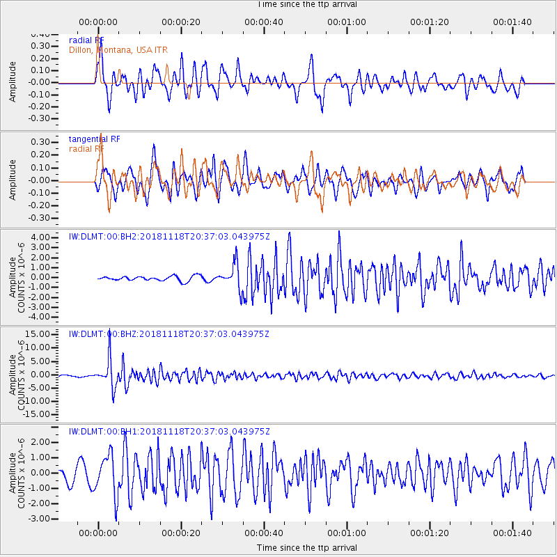
Signal To Noise
| Channel | StoN | STA | LTA |
| IW:DLMT:00:BHZ:20181118T20:37:03.043975Z | 17.00374 | 5.3344515E-6 | 3.1372224E-7 |
| IW:DLMT:00:BH1:20181118T20:37:03.043975Z | 2.977907 | 1.3540579E-6 | 4.547012E-7 |
| IW:DLMT:00:BH2:20181118T20:37:03.043975Z | 5.476508 | 1.2974753E-6 | 2.3691653E-7 |
| Arrivals |
| Ps | |
| PpPs | |
| PsPs/PpSs | |


