You are here: Home > Network List > LB - Leo Brady Network Stations List
> Station TPH Tonopah, Nevada, USA > Earthquake Result Viewer
TPH Tonopah, Nevada, USA - Earthquake Result Viewer
| Earthquake location: |
Fiji Islands Region |
| Earthquake latitude/longitude: |
-17.9/-178.9 |
| Earthquake time(UTC): |
2018/11/18 (322) 20:25:45 GMT |
| Earthquake Depth: |
534 km |
| Earthquake Magnitude: |
6.7 Mww |
| Earthquake Catalog/Contributor: |
NEIC PDE/us |
|
| Network: |
LB Leo Brady Network |
| Station: |
TPH Tonopah, Nevada, USA |
| Lat/Lon: |
38.08 N/117.22 W |
| Elevation: |
1883 m |
|
| Distance: |
80.3 deg |
| Az: |
44.819 deg |
| Baz: |
238.26 deg |
| Ray Param: |
0.046794746 |
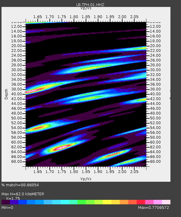
| Estimated Moho Depth: |
62.0 km |
| Estimated Crust Vp/Vs: |
1.75 |
| Assumed Crust Vp: |
6.276 km/s |
| Estimated Crust Vs: |
3.586 km/s |
| Estimated Crust Poisson's Ratio: |
0.26 |
|
| Radial Match: |
88.66854 % |
| Radial Bump: |
368 |
| Transverse Match: |
76.54069 % |
| Transverse Bump: |
351 |
| SOD ConfigId: |
3165032 |
| Insert Time: |
2018-12-02 20:34:42.428 +0000 |
| GWidth: |
2.5 |
| Max Bumps: |
400 |
| Tol: |
0.001 |
|

Signal To Noise
| Channel | StoN | STA | LTA |
| LB:TPH:01:HHZ:20181118T20:36:30.048003Z | 37.402515 | 3.2946286E-5 | 8.8085756E-7 |
| LB:TPH:01:HHN:20181118T20:36:30.048003Z | 8.537785 | 5.8817723E-6 | 6.889108E-7 |
| LB:TPH:01:HHE:20181118T20:36:30.048003Z | 13.985341 | 9.453013E-6 | 6.75923E-7 |
| Arrivals |
| Ps | 7.6 SECOND |
| PpPs | 26 SECOND |
| PsPs/PpSs | 34 SECOND |


