You are here: Home > Network List > IU - Global Seismograph Network (GSN - IRIS/USGS) Stations List
> Station PMG Port Moresby, New Guinea > Earthquake Result Viewer
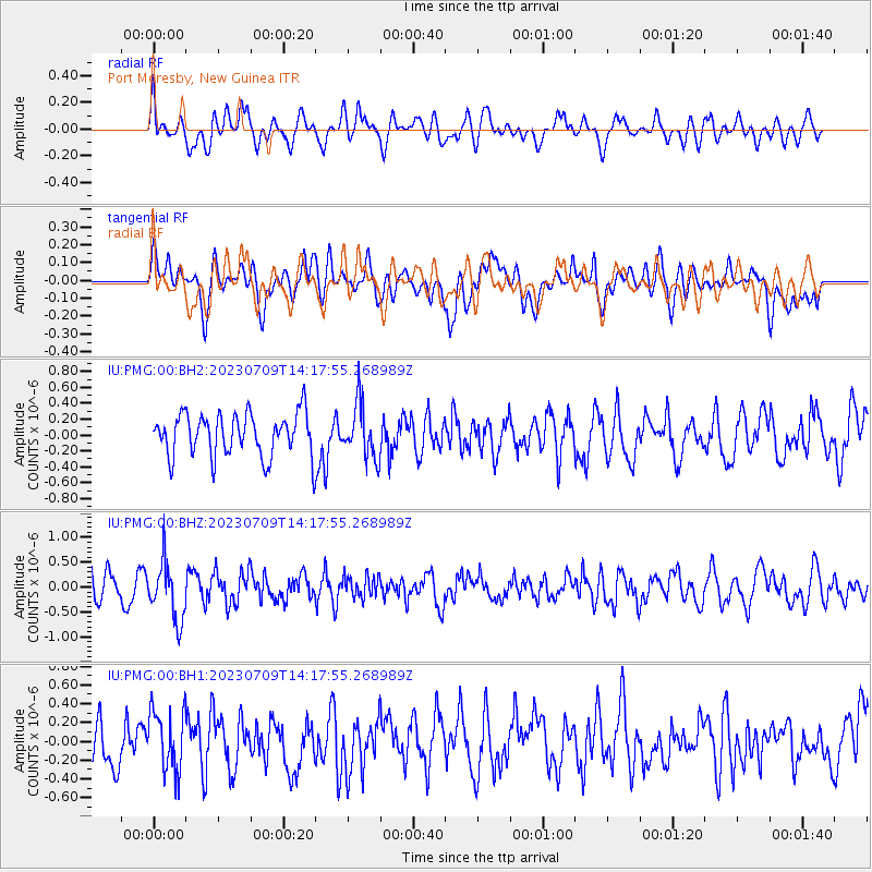
PMG Port Moresby, New Guinea - Earthquake Result Viewer
*The percent match for this event was below the threshold and hence no stack was calculated.
| Earthquake location: |
Northern Sumatra, Indonesia |
| Earthquake latitude/longitude: |
5.4/94.6 |
| Earthquake time(UTC): |
2023/07/09 (190) 14:09:04 GMT |
| Earthquake Depth: |
54 km |
| Earthquake Magnitude: |
5.4 Mww |
| Earthquake Catalog/Contributor: |
NEIC PDE/us |
|
| Network: |
IU Global Seismograph Network (GSN - IRIS/USGS) |
| Station: |
PMG Port Moresby, New Guinea |
| Lat/Lon: |
9.40 S/147.16 E |
| Elevation: |
90 m |
|
| Distance: |
54.4 deg |
| Az: |
105.489 deg |
| Baz: |
283.485 deg |
| Ray Param: |
$rayparam |
*The percent match for this event was below the threshold and hence was not used in the summary stack. |
|
| Radial Match: |
52.68126 % |
| Radial Bump: |
400 |
| Transverse Match: |
57.794773 % |
| Transverse Bump: |
400 |
| SOD ConfigId: |
30536071 |
| Insert Time: |
2023-07-23 14:18:01.812 +0000 |
| GWidth: |
2.5 |
| Max Bumps: |
400 |
| Tol: |
0.001 |
|
Signal To Noise
| Channel | StoN | STA | LTA |
| IU:PMG:00:BHZ:20230709T14:17:55.268989Z | 2.3483589 | 5.804356E-7 | 2.4716647E-7 |
| IU:PMG:00:BH1:20230709T14:17:55.268989Z | 1.1444042 | 3.313091E-7 | 2.895036E-7 |
| IU:PMG:00:BH2:20230709T14:17:55.268989Z | 1.266038 | 3.4041537E-7 | 2.6888245E-7 |
| Arrivals |
| Ps | |
| PpPs | |
| PsPs/PpSs | |


