You are here: Home > Network List > C0 - Colorado Geological Survey Seismic Network Stations List
> Station T25A Trinidad, CO > Earthquake Result Viewer
T25A Trinidad, CO - Earthquake Result Viewer
| Earthquake location: |
Chile-Argentina Border Region |
| Earthquake latitude/longitude: |
-33.2/-70.3 |
| Earthquake time(UTC): |
2023/07/09 (190) 17:11:33 GMT |
| Earthquake Depth: |
102 km |
| Earthquake Magnitude: |
5.6 Mww |
| Earthquake Catalog/Contributor: |
NEIC PDE/us |
|
| Network: |
C0 Colorado Geological Survey Seismic Network |
| Station: |
T25A Trinidad, CO |
| Lat/Lon: |
37.08 N/104.25 W |
| Elevation: |
1800 m |
|
| Distance: |
76.8 deg |
| Az: |
332.713 deg |
| Baz: |
151.276 deg |
| Ray Param: |
0.05054481 |
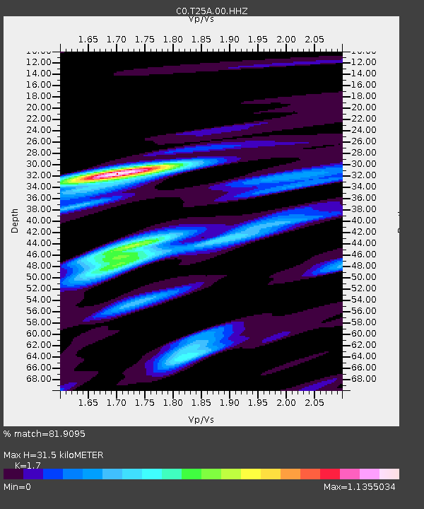
| Estimated Moho Depth: |
31.5 km |
| Estimated Crust Vp/Vs: |
1.70 |
| Assumed Crust Vp: |
6.316 km/s |
| Estimated Crust Vs: |
3.715 km/s |
| Estimated Crust Poisson's Ratio: |
0.24 |
|
| Radial Match: |
81.9095 % |
| Radial Bump: |
400 |
| Transverse Match: |
80.3884 % |
| Transverse Bump: |
400 |
| SOD ConfigId: |
30536071 |
| Insert Time: |
2023-07-23 17:16:00.924 +0000 |
| GWidth: |
2.5 |
| Max Bumps: |
400 |
| Tol: |
0.001 |
|

Signal To Noise
| Channel | StoN | STA | LTA |
| C0:T25A:00:HHZ:20230709T17:22:43.919003Z | 6.068692 | 3.3908591E-7 | 5.5874626E-8 |
| C0:T25A:00:HHN:20230709T17:22:43.919003Z | 1.6277065 | 1.02650496E-7 | 6.3064505E-8 |
| C0:T25A:00:HHE:20230709T17:22:43.919003Z | 1.4609456 | 6.674953E-8 | 4.5689262E-8 |
| Arrivals |
| Ps | 3.6 SECOND |
| PpPs | 13 SECOND |
| PsPs/PpSs | 17 SECOND |


