You are here: Home > Network List > GM - US Geological Survey Networks Stations List
> Station IWM01 Jericho 2M Well Monitoring Station > Earthquake Result Viewer
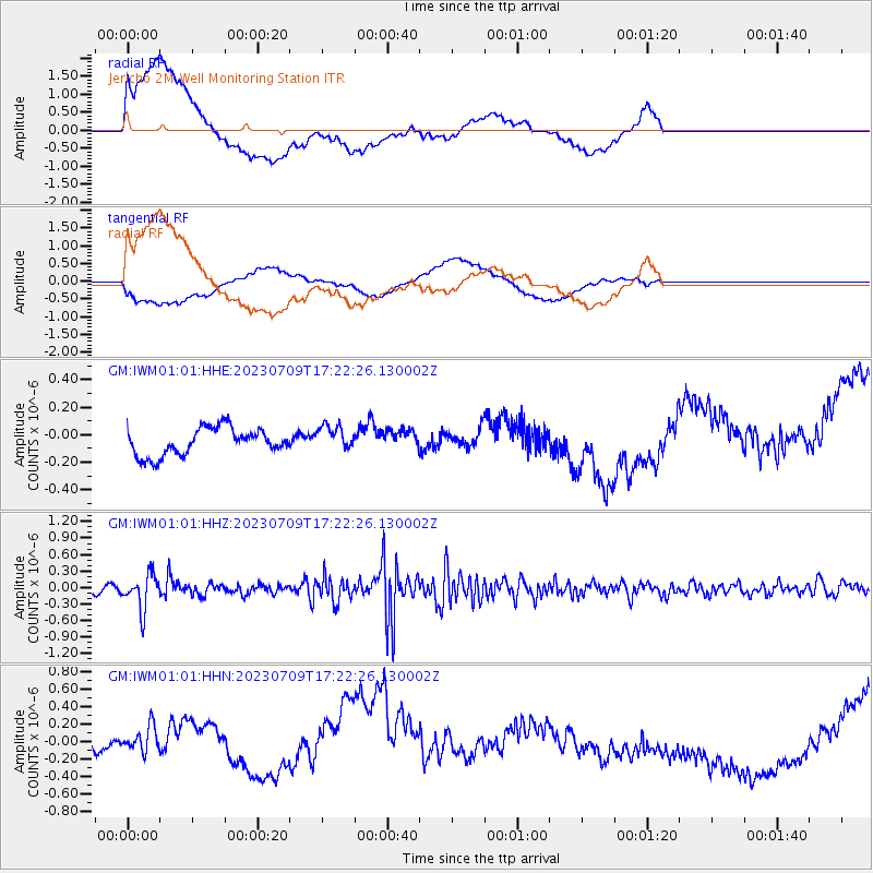
IWM01 Jericho 2M Well Monitoring Station - Earthquake Result Viewer
*The percent match for this event was below the threshold and hence no stack was calculated.
| Earthquake location: |
Chile-Argentina Border Region |
| Earthquake latitude/longitude: |
-33.2/-70.3 |
| Earthquake time(UTC): |
2023/07/09 (190) 17:11:33 GMT |
| Earthquake Depth: |
102 km |
| Earthquake Magnitude: |
5.6 Mww |
| Earthquake Catalog/Contributor: |
NEIC PDE/us |
|
| Network: |
GM US Geological Survey Networks |
| Station: |
IWM01 Jericho 2M Well Monitoring Station |
| Lat/Lon: |
36.73 N/96.53 W |
| Elevation: |
328 m |
|
| Distance: |
73.8 deg |
| Az: |
338.314 deg |
| Baz: |
157.32 deg |
| Ray Param: |
$rayparam |
*The percent match for this event was below the threshold and hence was not used in the summary stack. |
|
| Radial Match: |
53.97436 % |
| Radial Bump: |
400 |
| Transverse Match: |
28.78987 % |
| Transverse Bump: |
400 |
| SOD ConfigId: |
30536071 |
| Insert Time: |
2023-07-23 17:22:02.700 +0000 |
| GWidth: |
2.5 |
| Max Bumps: |
400 |
| Tol: |
0.001 |
|
Signal To Noise
| Channel | StoN | STA | LTA |
| GM:IWM01:01:HHZ:20230709T17:22:26.130002Z | 6.6957912 | 3.132953E-7 | 4.6789882E-8 |
| GM:IWM01:01:HHN:20230709T17:22:26.130002Z | 1.6798866 | 2.6471557E-7 | 1.5757944E-7 |
| GM:IWM01:01:HHE:20230709T17:22:26.130002Z | 0.94381326 | 9.2192444E-8 | 9.768082E-8 |
| Arrivals |
| Ps | |
| PpPs | |
| PsPs/PpSs | |


