You are here: Home > Network List > IW - Intermountain West Stations List
> Station MOOW Moose Ponds, Wyoming, USA > Earthquake Result Viewer
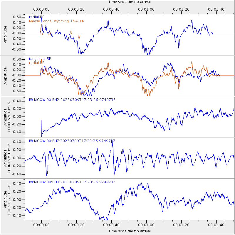
MOOW Moose Ponds, Wyoming, USA - Earthquake Result Viewer
*The percent match for this event was below the threshold and hence no stack was calculated.
| Earthquake location: |
Chile-Argentina Border Region |
| Earthquake latitude/longitude: |
-33.2/-70.3 |
| Earthquake time(UTC): |
2023/07/09 (190) 17:11:33 GMT |
| Earthquake Depth: |
102 km |
| Earthquake Magnitude: |
5.6 Mww |
| Earthquake Catalog/Contributor: |
NEIC PDE/us |
|
| Network: |
IW Intermountain West |
| Station: |
MOOW Moose Ponds, Wyoming, USA |
| Lat/Lon: |
43.75 N/110.74 W |
| Elevation: |
2128 m |
|
| Distance: |
85.0 deg |
| Az: |
331.859 deg |
| Baz: |
146.934 deg |
| Ray Param: |
$rayparam |
*The percent match for this event was below the threshold and hence was not used in the summary stack. |
|
| Radial Match: |
23.458342 % |
| Radial Bump: |
400 |
| Transverse Match: |
28.782892 % |
| Transverse Bump: |
400 |
| SOD ConfigId: |
30536071 |
| Insert Time: |
2023-07-23 17:23:50.340 +0000 |
| GWidth: |
2.5 |
| Max Bumps: |
400 |
| Tol: |
0.001 |
|
Signal To Noise
| Channel | StoN | STA | LTA |
| IW:MOOW:00:BHZ:20230709T17:23:26.974973Z | 5.022856 | 1.8206806E-7 | 3.624791E-8 |
| IW:MOOW:00:BH1:20230709T17:23:26.974973Z | 0.49979106 | 1.5162553E-7 | 3.0337782E-7 |
| IW:MOOW:00:BH2:20230709T17:23:26.974973Z | 1.388486 | 2.128811E-7 | 1.5331887E-7 |
| Arrivals |
| Ps | |
| PpPs | |
| PsPs/PpSs | |


