You are here: Home > Network List > TA - USArray Transportable Network (new EarthScope stations) Stations List
> Station L02D Cave Junction, OR, USA > Earthquake Result Viewer
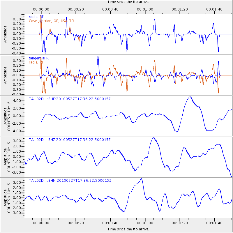
L02D Cave Junction, OR, USA - Earthquake Result Viewer
*The percent match for this event was below the threshold and hence no stack was calculated.
| Earthquake location: |
Vanuatu Islands |
| Earthquake latitude/longitude: |
-13.9/166.7 |
| Earthquake time(UTC): |
2010/05/27 (147) 17:24:23 GMT |
| Earthquake Depth: |
35 km |
| Earthquake Magnitude: |
5.6 MB |
| Earthquake Catalog/Contributor: |
WHDF/NEIC |
|
| Network: |
TA USArray Transportable Network (new EarthScope stations) |
| Station: |
L02D Cave Junction, OR, USA |
| Lat/Lon: |
42.16 N/123.60 W |
| Elevation: |
458 m |
|
| Distance: |
84.8 deg |
| Az: |
44.438 deg |
| Baz: |
246.131 deg |
| Ray Param: |
$rayparam |
*The percent match for this event was below the threshold and hence was not used in the summary stack. |
|
| Radial Match: |
47.0877 % |
| Radial Bump: |
309 |
| Transverse Match: |
54.297127 % |
| Transverse Bump: |
400 |
| SOD ConfigId: |
314592 |
| Insert Time: |
2010-09-14 07:52:14.216 +0000 |
| GWidth: |
2.5 |
| Max Bumps: |
400 |
| Tol: |
0.001 |
|
Signal To Noise
| Channel | StoN | STA | LTA |
| TA:L02D: :BHZ:20100527T17:36:22.500015Z | 0.8223567 | 7.233349E-7 | 8.7958773E-7 |
| TA:L02D: :BHN:20100527T17:36:22.500015Z | 1.0040383 | 3.321678E-7 | 3.308318E-7 |
| TA:L02D: :BHE:20100527T17:36:22.500015Z | 1.5895079 | 8.335929E-7 | 5.2443454E-7 |
| Arrivals |
| Ps | |
| PpPs | |
| PsPs/PpSs | |


