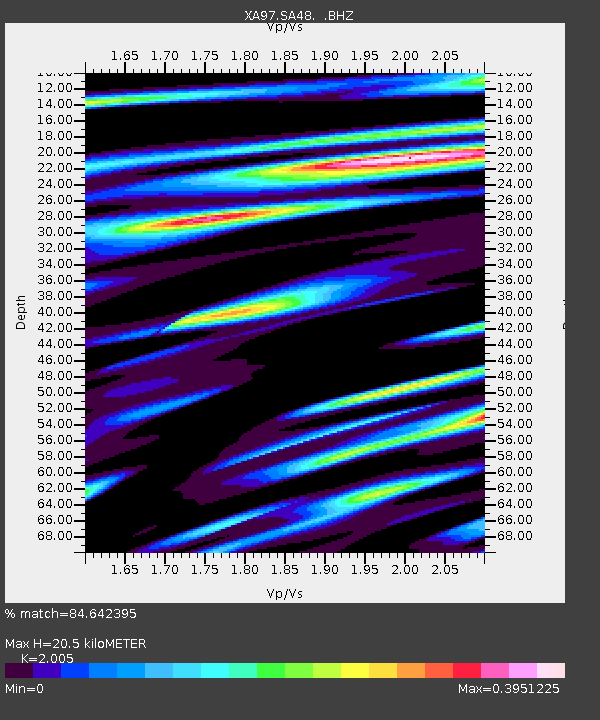
SA48 XA.SA48 - Earthquake Result Viewer

Earthquake location: Minahassa Peninsula, Sulawesi
Earthquake latitude/longitude: 0.2/119.6
Earthquake time(UTC): 1998/05/21 (141) 05:34:25 GMT
Earthquake Depth: 33 km
Earthquake Magnitude: 6.2 MB, 6.3 MS, 6.6 UNKNOWN, 6.6 MW
Earthquake Catalog/Contributor: WHDF/NEIC
Network: XA Anatomy of an Archean Craton, South Africa
Station: SA48 XA.SA48
Lat/Lon: 24.89 S/29.22 E
Elevation: 1000 m
Distance: 90.4 deg
Az: 245.253 deg
Baz: 89.967 deg
Ray Param: 0.041670684
Estimated Moho Depth: 20.5 km
Estimated Crust Vp/Vs: 2.01
Assumed Crust Vp: 6.459 km/s
Estimated Crust Vs: 3.222 km/s
Estimated Crust Poisson's Ratio: 0.33
Radial Match: 84.642395 %
Radial Bump: 400
Transverse Match: 82.04863 %
Transverse Bump: 388
SOD ConfigId: 4480
Insert Time: 2010-02-26 18:16:58.165 +0000
GWidth: 2.5
Max Bumps: 400
Tol: 0.001

Signal To Noise

ChannelStoNSTALTA
XA:SA48: :BHZ:19980521T05:46:52.322998Z1.71140651.231799E-67.1975836E-7
XA:SA48: :BHN:19980521T05:46:52.322998Z1.20595745.69537E-74.722696E-7
XA:SA48: :BHE:19980521T05:46:52.322998Z0.77757832.8664948E-73.686439E-7
Arrivals
Ps3.2 SECOND
PpPs9.4 SECOND
PsPs/PpSs13 SECOND