You are here: Home > Network List > NM - Cooperative New Madrid Seismic Network Stations List
> Station PENM Penman,Portageville,MO > Earthquake Result Viewer
PENM Penman,Portageville,MO - Earthquake Result Viewer
| Earthquake location: |
Chile-Argentina Border Region |
| Earthquake latitude/longitude: |
-33.2/-70.3 |
| Earthquake time(UTC): |
2023/07/09 (190) 17:11:33 GMT |
| Earthquake Depth: |
102 km |
| Earthquake Magnitude: |
5.6 Mww |
| Earthquake Catalog/Contributor: |
NEIC PDE/us |
|
| Network: |
NM Cooperative New Madrid Seismic Network |
| Station: |
PENM Penman,Portageville,MO |
| Lat/Lon: |
36.45 N/89.63 W |
| Elevation: |
85 m |
|
| Distance: |
71.6 deg |
| Az: |
343.69 deg |
| Baz: |
163.022 deg |
| Ray Param: |
0.053969212 |
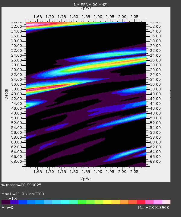
| Estimated Moho Depth: |
11.0 km |
| Estimated Crust Vp/Vs: |
1.60 |
| Assumed Crust Vp: |
6.444 km/s |
| Estimated Crust Vs: |
4.027 km/s |
| Estimated Crust Poisson's Ratio: |
0.18 |
|
| Radial Match: |
80.996025 % |
| Radial Bump: |
400 |
| Transverse Match: |
62.62236 % |
| Transverse Bump: |
400 |
| SOD ConfigId: |
30536071 |
| Insert Time: |
2023-07-23 17:28:24.506 +0000 |
| GWidth: |
2.5 |
| Max Bumps: |
400 |
| Tol: |
0.001 |
|

Signal To Noise
| Channel | StoN | STA | LTA |
| NM:PENM:00:HHZ:20230709T17:22:13.470029Z | 3.018832 | 9.311543E-7 | 3.0844853E-7 |
| NM:PENM:00:HHN:20230709T17:22:13.470029Z | 1.7536747 | 7.6574236E-7 | 4.3665017E-7 |
| NM:PENM:00:HHE:20230709T17:22:13.470029Z | 1.12511 | 4.3559777E-7 | 3.8716016E-7 |
| Arrivals |
| Ps | 1.1 SECOND |
| PpPs | 4.3 SECOND |
| PsPs/PpSs | 5.3 SECOND |


