You are here: Home > Network List > US - United States National Seismic Network Stations List
> Station LAO LASA Array, Montana, USA > Earthquake Result Viewer
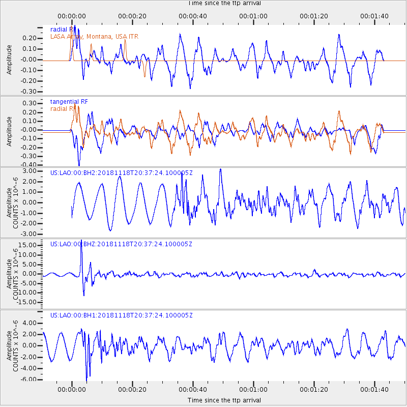
LAO LASA Array, Montana, USA - Earthquake Result Viewer
*The percent match for this event was below the threshold and hence no stack was calculated.
| Earthquake location: |
Fiji Islands Region |
| Earthquake latitude/longitude: |
-17.9/-178.9 |
| Earthquake time(UTC): |
2018/11/18 (322) 20:25:45 GMT |
| Earthquake Depth: |
534 km |
| Earthquake Magnitude: |
6.7 Mww |
| Earthquake Catalog/Contributor: |
NEIC PDE/us |
|
| Network: |
US United States National Seismic Network |
| Station: |
LAO LASA Array, Montana, USA |
| Lat/Lon: |
46.69 N/106.22 W |
| Elevation: |
902 m |
|
| Distance: |
91.5 deg |
| Az: |
41.102 deg |
| Baz: |
245.414 deg |
| Ray Param: |
$rayparam |
*The percent match for this event was below the threshold and hence was not used in the summary stack. |
|
| Radial Match: |
47.663094 % |
| Radial Bump: |
349 |
| Transverse Match: |
38.879814 % |
| Transverse Bump: |
334 |
| SOD ConfigId: |
3165032 |
| Insert Time: |
2018-12-02 20:37:01.341 +0000 |
| GWidth: |
2.5 |
| Max Bumps: |
400 |
| Tol: |
0.001 |
|
Signal To Noise
| Channel | StoN | STA | LTA |
| US:LAO:00:BHZ:20181118T20:37:24.100005Z | 10.598219 | 5.367699E-6 | 5.064718E-7 |
| US:LAO:00:BH1:20181118T20:37:24.100005Z | 1.7511061 | 2.1976307E-6 | 1.2549957E-6 |
| US:LAO:00:BH2:20181118T20:37:24.100005Z | 1.013451 | 1.4294615E-6 | 1.4104891E-6 |
| Arrivals |
| Ps | |
| PpPs | |
| PsPs/PpSs | |


