You are here: Home > Network List > US - United States National Seismic Network Stations List
> Station MSO Missoula, Montana, USA > Earthquake Result Viewer
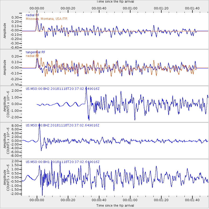
MSO Missoula, Montana, USA - Earthquake Result Viewer
*The percent match for this event was below the threshold and hence no stack was calculated.
| Earthquake location: |
Fiji Islands Region |
| Earthquake latitude/longitude: |
-17.9/-178.9 |
| Earthquake time(UTC): |
2018/11/18 (322) 20:25:45 GMT |
| Earthquake Depth: |
534 km |
| Earthquake Magnitude: |
6.7 Mww |
| Earthquake Catalog/Contributor: |
NEIC PDE/us |
|
| Network: |
US United States National Seismic Network |
| Station: |
MSO Missoula, Montana, USA |
| Lat/Lon: |
46.83 N/113.94 W |
| Elevation: |
1264 m |
|
| Distance: |
86.9 deg |
| Az: |
38.536 deg |
| Baz: |
239.769 deg |
| Ray Param: |
$rayparam |
*The percent match for this event was below the threshold and hence was not used in the summary stack. |
|
| Radial Match: |
67.19584 % |
| Radial Bump: |
400 |
| Transverse Match: |
63.82743 % |
| Transverse Bump: |
400 |
| SOD ConfigId: |
3165032 |
| Insert Time: |
2018-12-02 20:37:07.825 +0000 |
| GWidth: |
2.5 |
| Max Bumps: |
400 |
| Tol: |
0.001 |
|
Signal To Noise
| Channel | StoN | STA | LTA |
| US:MSO:00:BHZ:20181118T20:37:02.649016Z | 13.322491 | 3.4312243E-6 | 2.5755128E-7 |
| US:MSO:00:BH1:20181118T20:37:02.649016Z | 2.2702057 | 7.554864E-7 | 3.3278323E-7 |
| US:MSO:00:BH2:20181118T20:37:02.649016Z | 7.754564 | 1.2043031E-6 | 1.5530249E-7 |
| Arrivals |
| Ps | |
| PpPs | |
| PsPs/PpSs | |


