You are here: Home > Network List > 1E - GSC-BCOGC Induced Seismicity Study Stations List
> Station MONT3 Z > Earthquake Result Viewer
MONT3 Z - Earthquake Result Viewer
| Earthquake location: |
North Atlantic Ocean |
| Earthquake latitude/longitude: |
20.0/-61.1 |
| Earthquake time(UTC): |
2023/07/10 (191) 20:28:25 GMT |
| Earthquake Depth: |
10 km |
| Earthquake Magnitude: |
6.6 mww |
| Earthquake Catalog/Contributor: |
NEIC PDE/us |
|
| Network: |
1E GSC-BCOGC Induced Seismicity Study |
| Station: |
MONT3 Z |
| Lat/Lon: |
56.01 N/120.45 W |
| Elevation: |
783 m |
|
| Distance: |
56.6 deg |
| Az: |
324.621 deg |
| Baz: |
104.242 deg |
| Ray Param: |
0.064049885 |
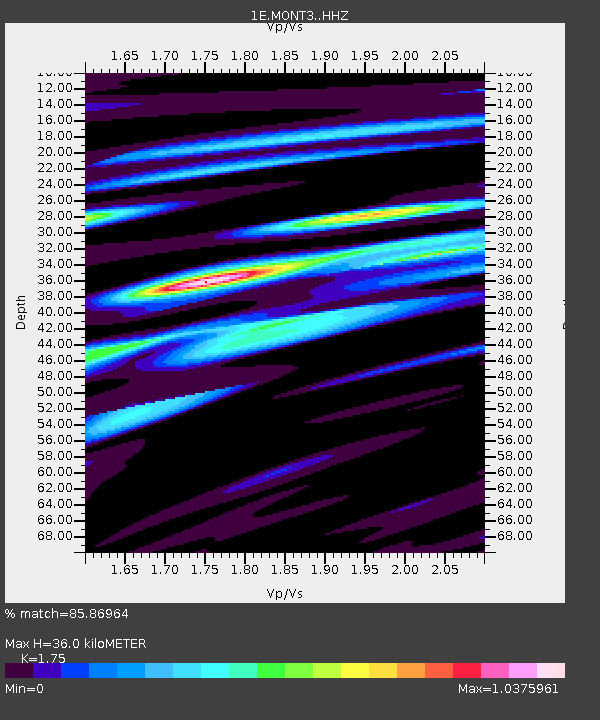
| Estimated Moho Depth: |
36.0 km |
| Estimated Crust Vp/Vs: |
1.75 |
| Assumed Crust Vp: |
6.291 km/s |
| Estimated Crust Vs: |
3.595 km/s |
| Estimated Crust Poisson's Ratio: |
0.26 |
|
| Radial Match: |
85.86964 % |
| Radial Bump: |
400 |
| Transverse Match: |
69.27784 % |
| Transverse Bump: |
400 |
| SOD ConfigId: |
30536071 |
| Insert Time: |
2023-07-24 20:29:50.546 +0000 |
| GWidth: |
2.5 |
| Max Bumps: |
400 |
| Tol: |
0.001 |
|

Signal To Noise
| Channel | StoN | STA | LTA |
| 1E:MONT3: :HHZ:20230710T20:37:37.470003Z | 8.615086 | 6.366082E-7 | 7.389458E-8 |
| 1E:MONT3: :HHN:20230710T20:37:37.470003Z | 0.72817546 | 1.0806755E-7 | 1.4840867E-7 |
| 1E:MONT3: :HHE:20230710T20:37:37.470003Z | 2.1145558 | 3.22064E-7 | 1.5230812E-7 |
| Arrivals |
| Ps | 4.5 SECOND |
| PpPs | 15 SECOND |
| PsPs/PpSs | 19 SECOND |


