You are here: Home > Network List > AK - Alaska Regional Network Stations List
> Station S31K Pelican, AK, USA > Earthquake Result Viewer
S31K Pelican, AK, USA - Earthquake Result Viewer
| Earthquake location: |
North Atlantic Ocean |
| Earthquake latitude/longitude: |
20.0/-61.1 |
| Earthquake time(UTC): |
2023/07/10 (191) 20:28:25 GMT |
| Earthquake Depth: |
10 km |
| Earthquake Magnitude: |
6.6 mww |
| Earthquake Catalog/Contributor: |
NEIC PDE/us |
|
| Network: |
AK Alaska Regional Network |
| Station: |
S31K Pelican, AK, USA |
| Lat/Lon: |
57.96 N/136.23 W |
| Elevation: |
34 m |
|
| Distance: |
65.4 deg |
| Az: |
325.479 deg |
| Baz: |
91.429 deg |
| Ray Param: |
0.058307476 |
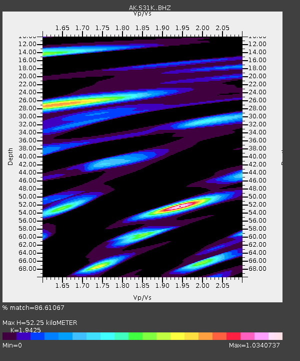
| Estimated Moho Depth: |
52.25 km |
| Estimated Crust Vp/Vs: |
1.94 |
| Assumed Crust Vp: |
6.134 km/s |
| Estimated Crust Vs: |
3.158 km/s |
| Estimated Crust Poisson's Ratio: |
0.32 |
|
| Radial Match: |
86.61067 % |
| Radial Bump: |
400 |
| Transverse Match: |
75.12434 % |
| Transverse Bump: |
400 |
| SOD ConfigId: |
30536071 |
| Insert Time: |
2023-07-24 20:37:25.517 +0000 |
| GWidth: |
2.5 |
| Max Bumps: |
400 |
| Tol: |
0.001 |
|

Signal To Noise
| Channel | StoN | STA | LTA |
| AK:S31K: :BHZ:20230710T20:38:37.160005Z | 2.3768523 | 2.563256E-7 | 1.0784246E-7 |
| AK:S31K: :BHN:20230710T20:38:37.160005Z | 1.3616507 | 9.3483195E-8 | 6.8654316E-8 |
| AK:S31K: :BHE:20230710T20:38:37.160005Z | 1.1315926 | 1.4492369E-7 | 1.2807054E-7 |
| Arrivals |
| Ps | 8.3 SECOND |
| PpPs | 24 SECOND |
| PsPs/PpSs | 33 SECOND |


