You are here: Home > Network List > AK - Alaska Regional Network Stations List
> Station V35K Ketchikan, AK, USA > Earthquake Result Viewer
V35K Ketchikan, AK, USA - Earthquake Result Viewer
| Earthquake location: |
North Atlantic Ocean |
| Earthquake latitude/longitude: |
20.0/-61.1 |
| Earthquake time(UTC): |
2023/07/10 (191) 20:28:25 GMT |
| Earthquake Depth: |
10 km |
| Earthquake Magnitude: |
6.6 mww |
| Earthquake Catalog/Contributor: |
NEIC PDE/us |
|
| Network: |
AK Alaska Regional Network |
| Station: |
V35K Ketchikan, AK, USA |
| Lat/Lon: |
55.33 N/131.62 W |
| Elevation: |
64 m |
|
| Distance: |
62.7 deg |
| Az: |
322.684 deg |
| Baz: |
94.056 deg |
| Ray Param: |
0.060046855 |
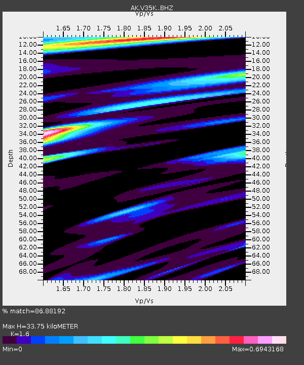
| Estimated Moho Depth: |
33.75 km |
| Estimated Crust Vp/Vs: |
1.60 |
| Assumed Crust Vp: |
6.545 km/s |
| Estimated Crust Vs: |
4.091 km/s |
| Estimated Crust Poisson's Ratio: |
0.18 |
|
| Radial Match: |
86.88192 % |
| Radial Bump: |
400 |
| Transverse Match: |
65.698044 % |
| Transverse Bump: |
400 |
| SOD ConfigId: |
30536071 |
| Insert Time: |
2023-07-24 20:37:44.844 +0000 |
| GWidth: |
2.5 |
| Max Bumps: |
400 |
| Tol: |
0.001 |
|

Signal To Noise
| Channel | StoN | STA | LTA |
| AK:V35K: :BHZ:20230710T20:38:19.639986Z | 3.0956097 | 3.2199526E-7 | 1.0401674E-7 |
| AK:V35K: :BHN:20230710T20:38:19.639986Z | 1.9116318 | 1.2246367E-7 | 6.406238E-8 |
| AK:V35K: :BHE:20230710T20:38:19.639986Z | 1.42007 | 1.0437396E-7 | 7.349916E-8 |
| Arrivals |
| Ps | 3.3 SECOND |
| PpPs | 13 SECOND |
| PsPs/PpSs | 16 SECOND |


