You are here: Home > Network List > AV - Alaska Volcano Observatory Stations List
> Station N20K Mount Spurr, AK, USA > Earthquake Result Viewer
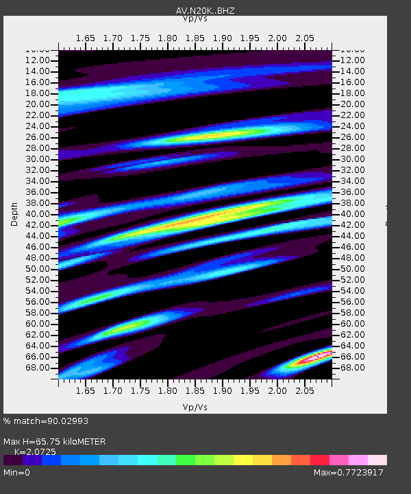
N20K Mount Spurr, AK, USA - Earthquake Result Viewer
| Earthquake location: |
North Atlantic Ocean |
| Earthquake latitude/longitude: |
20.0/-61.1 |
| Earthquake time(UTC): |
2023/07/10 (191) 20:28:25 GMT |
| Earthquake Depth: |
10 km |
| Earthquake Magnitude: |
6.6 mww |
| Earthquake Catalog/Contributor: |
NEIC PDE/us |
|
| Network: |
AV Alaska Volcano Observatory |
| Station: |
N20K Mount Spurr, AK, USA |
| Lat/Lon: |
61.20 N/152.21 W |
| Elevation: |
991 m |
|
| Distance: |
73.2 deg |
| Az: |
329.621 deg |
| Baz: |
79.115 deg |
| Ray Param: |
0.053159248 |
| Estimated Moho Depth: |
65.75 km |
| Estimated Crust Vp/Vs: |
2.07 |
| Assumed Crust Vp: |
6.566 km/s |
| Estimated Crust Vs: |
3.168 km/s |
| Estimated Crust Poisson's Ratio: |
0.35 |
|
| Radial Match: |
90.02993 % |
| Radial Bump: |
400 |
| Transverse Match: |
85.51071 % |
| Transverse Bump: |
400 |
| SOD ConfigId: |
30536071 |
| Insert Time: |
2023-07-24 20:40:34.806 +0000 |
| GWidth: |
2.5 |
| Max Bumps: |
400 |
| Tol: |
0.001 |
|

Signal To Noise
| Channel | StoN | STA | LTA |
| AV:N20K: :BHZ:20230710T20:39:25.475008Z | 12.734885 | 5.816999E-7 | 4.5677673E-8 |
| AV:N20K: :BHN:20230710T20:39:25.475008Z | 1.8241143 | 1.0190661E-7 | 5.5866348E-8 |
| AV:N20K: :BHE:20230710T20:39:25.475008Z | 4.7511787 | 2.8294332E-7 | 5.9552235E-8 |
| Arrivals |
| Ps | 11 SECOND |
| PpPs | 30 SECOND |
| PsPs/PpSs | 41 SECOND |


