You are here: Home > Network List > AV - Alaska Volcano Observatory Stations List
> Station SPCP Crater Peak Broadband, Mount Spurr, Alaska > Earthquake Result Viewer
SPCP Crater Peak Broadband, Mount Spurr, Alaska - Earthquake Result Viewer
| Earthquake location: |
North Atlantic Ocean |
| Earthquake latitude/longitude: |
20.0/-61.1 |
| Earthquake time(UTC): |
2023/07/10 (191) 20:28:25 GMT |
| Earthquake Depth: |
10 km |
| Earthquake Magnitude: |
6.6 mww |
| Earthquake Catalog/Contributor: |
NEIC PDE/us |
|
| Network: |
AV Alaska Volcano Observatory |
| Station: |
SPCP Crater Peak Broadband, Mount Spurr, Alaska |
| Lat/Lon: |
61.27 N/152.15 W |
| Elevation: |
1616 m |
|
| Distance: |
73.2 deg |
| Az: |
329.684 deg |
| Baz: |
79.18 deg |
| Ray Param: |
0.05318526 |
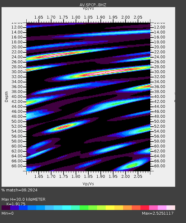
| Estimated Moho Depth: |
30.0 km |
| Estimated Crust Vp/Vs: |
1.92 |
| Assumed Crust Vp: |
6.566 km/s |
| Estimated Crust Vs: |
3.424 km/s |
| Estimated Crust Poisson's Ratio: |
0.31 |
|
| Radial Match: |
89.2924 % |
| Radial Bump: |
400 |
| Transverse Match: |
88.64388 % |
| Transverse Bump: |
400 |
| SOD ConfigId: |
30536071 |
| Insert Time: |
2023-07-24 20:41:38.240 +0000 |
| GWidth: |
2.5 |
| Max Bumps: |
400 |
| Tol: |
0.001 |
|

Signal To Noise
| Channel | StoN | STA | LTA |
| AV:SPCP: :BHZ:20230710T20:39:25.248018Z | 9.915635 | 6.966232E-7 | 7.025503E-8 |
| AV:SPCP: :BHN:20230710T20:39:25.248018Z | 2.384954 | 2.2364992E-7 | 9.377536E-8 |
| AV:SPCP: :BHE:20230710T20:39:25.248018Z | 3.3160372 | 4.0104842E-7 | 1.2094208E-7 |
| Arrivals |
| Ps | 4.3 SECOND |
| PpPs | 13 SECOND |
| PsPs/PpSs | 17 SECOND |


