You are here: Home > Network List > CC - Cascade Chain Volcano Monitoring Stations List
> Station MILD Mildred Point > Earthquake Result Viewer
MILD Mildred Point - Earthquake Result Viewer
| Earthquake location: |
North Atlantic Ocean |
| Earthquake latitude/longitude: |
20.0/-61.1 |
| Earthquake time(UTC): |
2023/07/10 (191) 20:28:25 GMT |
| Earthquake Depth: |
10 km |
| Earthquake Magnitude: |
6.6 mww |
| Earthquake Catalog/Contributor: |
NEIC PDE/us |
|
| Network: |
CC Cascade Chain Volcano Monitoring |
| Station: |
MILD Mildred Point |
| Lat/Lon: |
46.81 N/121.78 W |
| Elevation: |
2016 m |
|
| Distance: |
55.7 deg |
| Az: |
313.53 deg |
| Baz: |
97.015 deg |
| Ray Param: |
0.064631514 |
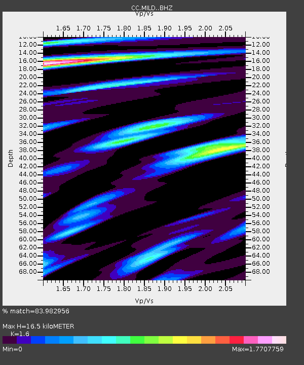
| Estimated Moho Depth: |
16.5 km |
| Estimated Crust Vp/Vs: |
1.60 |
| Assumed Crust Vp: |
6.597 km/s |
| Estimated Crust Vs: |
4.123 km/s |
| Estimated Crust Poisson's Ratio: |
0.18 |
|
| Radial Match: |
83.982956 % |
| Radial Bump: |
400 |
| Transverse Match: |
80.87361 % |
| Transverse Bump: |
400 |
| SOD ConfigId: |
30536071 |
| Insert Time: |
2023-07-24 20:46:41.930 +0000 |
| GWidth: |
2.5 |
| Max Bumps: |
400 |
| Tol: |
0.001 |
|

Signal To Noise
| Channel | StoN | STA | LTA |
| CC:MILD: :BHZ:20230710T20:37:31.139986Z | 11.827749 | 5.13505E-7 | 4.3415273E-8 |
| CC:MILD: :BHN:20230710T20:37:31.139986Z | 1.7191349 | 1.06906036E-7 | 6.218595E-8 |
| CC:MILD: :BHE:20230710T20:37:31.139986Z | 3.5080273 | 2.2644983E-7 | 6.45519E-8 |
| Arrivals |
| Ps | 1.6 SECOND |
| PpPs | 6.1 SECOND |
| PsPs/PpSs | 7.7 SECOND |


