You are here: Home > Network List > CC - Cascade Chain Volcano Monitoring Stations List
> Station PANH Panhandle Gap > Earthquake Result Viewer
PANH Panhandle Gap - Earthquake Result Viewer
| Earthquake location: |
North Atlantic Ocean |
| Earthquake latitude/longitude: |
20.0/-61.1 |
| Earthquake time(UTC): |
2023/07/10 (191) 20:28:25 GMT |
| Earthquake Depth: |
10 km |
| Earthquake Magnitude: |
6.6 mww |
| Earthquake Catalog/Contributor: |
NEIC PDE/us |
|
| Network: |
CC Cascade Chain Volcano Monitoring |
| Station: |
PANH Panhandle Gap |
| Lat/Lon: |
46.86 N/121.64 W |
| Elevation: |
2086 m |
|
| Distance: |
55.6 deg |
| Az: |
313.605 deg |
| Baz: |
97.154 deg |
| Ray Param: |
0.06467492 |
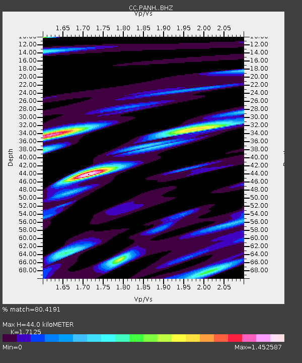
| Estimated Moho Depth: |
44.0 km |
| Estimated Crust Vp/Vs: |
1.71 |
| Assumed Crust Vp: |
6.597 km/s |
| Estimated Crust Vs: |
3.853 km/s |
| Estimated Crust Poisson's Ratio: |
0.24 |
|
| Radial Match: |
80.4191 % |
| Radial Bump: |
400 |
| Transverse Match: |
70.3951 % |
| Transverse Bump: |
400 |
| SOD ConfigId: |
30536071 |
| Insert Time: |
2023-07-24 20:46:49.299 +0000 |
| GWidth: |
2.5 |
| Max Bumps: |
400 |
| Tol: |
0.001 |
|

Signal To Noise
| Channel | StoN | STA | LTA |
| CC:PANH: :BHZ:20230710T20:37:30.54001Z | 10.781452 | 5.674701E-7 | 5.263392E-8 |
| CC:PANH: :BHN:20230710T20:37:30.54001Z | 1.2093618 | 1.3355398E-7 | 1.1043343E-7 |
| CC:PANH: :BHE:20230710T20:37:30.54001Z | 1.4294249 | 2.3297376E-7 | 1.6298426E-7 |
| Arrivals |
| Ps | 5.0 SECOND |
| PpPs | 17 SECOND |
| PsPs/PpSs | 22 SECOND |


