You are here: Home > Network List > CN - Canadian National Seismograph Network Stations List
> Station GDR Gold River, BC, CA > Earthquake Result Viewer
GDR Gold River, BC, CA - Earthquake Result Viewer
| Earthquake location: |
North Atlantic Ocean |
| Earthquake latitude/longitude: |
20.0/-61.1 |
| Earthquake time(UTC): |
2023/07/10 (191) 20:28:25 GMT |
| Earthquake Depth: |
10 km |
| Earthquake Magnitude: |
6.6 mww |
| Earthquake Catalog/Contributor: |
NEIC PDE/us |
|
| Network: |
CN Canadian National Seismograph Network |
| Station: |
GDR Gold River, BC, CA |
| Lat/Lon: |
49.78 N/126.06 W |
| Elevation: |
123 m |
|
| Distance: |
58.9 deg |
| Az: |
316.671 deg |
| Baz: |
95.527 deg |
| Ray Param: |
0.06256862 |
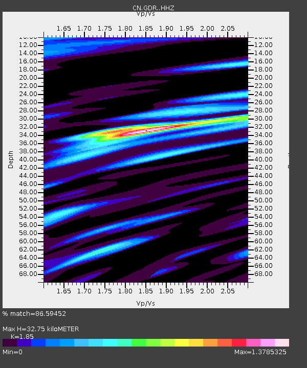
| Estimated Moho Depth: |
32.75 km |
| Estimated Crust Vp/Vs: |
1.85 |
| Assumed Crust Vp: |
6.24 km/s |
| Estimated Crust Vs: |
3.373 km/s |
| Estimated Crust Poisson's Ratio: |
0.29 |
|
| Radial Match: |
86.59452 % |
| Radial Bump: |
400 |
| Transverse Match: |
75.85988 % |
| Transverse Bump: |
400 |
| SOD ConfigId: |
30536071 |
| Insert Time: |
2023-07-24 20:52:22.923 +0000 |
| GWidth: |
2.5 |
| Max Bumps: |
400 |
| Tol: |
0.001 |
|

Signal To Noise
| Channel | StoN | STA | LTA |
| CN:GDR: :HHZ:20230710T20:37:53.459993Z | 4.0875797 | 3.5310927E-7 | 8.63859E-8 |
| CN:GDR: :HHN:20230710T20:37:53.459993Z | 1.1999602 | 8.18619E-8 | 6.8220515E-8 |
| CN:GDR: :HHE:20230710T20:37:53.459993Z | 2.3622003 | 1.8254943E-7 | 7.727941E-8 |
| Arrivals |
| Ps | 4.7 SECOND |
| PpPs | 14 SECOND |
| PsPs/PpSs | 19 SECOND |


