You are here: Home > Network List > WY - Yellowstone Wyoming Seismic Network Stations List
> Station YHB Horse Butte YNP, MT, USA > Earthquake Result Viewer
YHB Horse Butte YNP, MT, USA - Earthquake Result Viewer
| Earthquake location: |
Fiji Islands Region |
| Earthquake latitude/longitude: |
-17.9/-178.9 |
| Earthquake time(UTC): |
2018/11/18 (322) 20:25:45 GMT |
| Earthquake Depth: |
534 km |
| Earthquake Magnitude: |
6.7 Mww |
| Earthquake Catalog/Contributor: |
NEIC PDE/us |
|
| Network: |
WY Yellowstone Wyoming Seismic Network |
| Station: |
YHB Horse Butte YNP, MT, USA |
| Lat/Lon: |
44.75 N/111.20 W |
| Elevation: |
2167 m |
|
| Distance: |
87.5 deg |
| Az: |
41.29 deg |
| Baz: |
241.865 deg |
| Ray Param: |
0.041778985 |
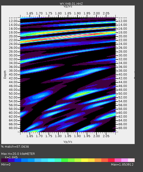
| Estimated Moho Depth: |
20.0 km |
| Estimated Crust Vp/Vs: |
1.85 |
| Assumed Crust Vp: |
6.35 km/s |
| Estimated Crust Vs: |
3.442 km/s |
| Estimated Crust Poisson's Ratio: |
0.29 |
|
| Radial Match: |
87.0636 % |
| Radial Bump: |
400 |
| Transverse Match: |
76.67019 % |
| Transverse Bump: |
400 |
| SOD ConfigId: |
3165032 |
| Insert Time: |
2018-12-02 20:38:33.646 +0000 |
| GWidth: |
2.5 |
| Max Bumps: |
400 |
| Tol: |
0.001 |
|

Signal To Noise
| Channel | StoN | STA | LTA |
| WY:YHB:01:HHZ:20181118T20:37:05.745024Z | 12.700475 | 1.795402E-7 | 1.4136494E-8 |
| WY:YHB:01:HHN:20181118T20:37:05.745024Z | 1.9897034 | 4.1515182E-8 | 2.0865011E-8 |
| WY:YHB:01:HHE:20181118T20:37:05.745024Z | 4.941832 | 5.2010446E-8 | 1.0524527E-8 |
| Arrivals |
| Ps | 2.7 SECOND |
| PpPs | 8.8 SECOND |
| PsPs/PpSs | 12 SECOND |


