You are here: Home > Network List > CN - Canadian National Seismograph Network Stations List
> Station PACB Port Alice, BC, CA > Earthquake Result Viewer
PACB Port Alice, BC, CA - Earthquake Result Viewer
| Earthquake location: |
North Atlantic Ocean |
| Earthquake latitude/longitude: |
20.0/-61.1 |
| Earthquake time(UTC): |
2023/07/10 (191) 20:28:25 GMT |
| Earthquake Depth: |
10 km |
| Earthquake Magnitude: |
6.6 mww |
| Earthquake Catalog/Contributor: |
NEIC PDE/us |
|
| Network: |
CN Canadian National Seismograph Network |
| Station: |
PACB Port Alice, BC, CA |
| Lat/Lon: |
50.44 N/127.49 W |
| Elevation: |
24 m |
|
| Distance: |
59.8 deg |
| Az: |
317.333 deg |
| Baz: |
94.765 deg |
| Ray Param: |
0.06192279 |
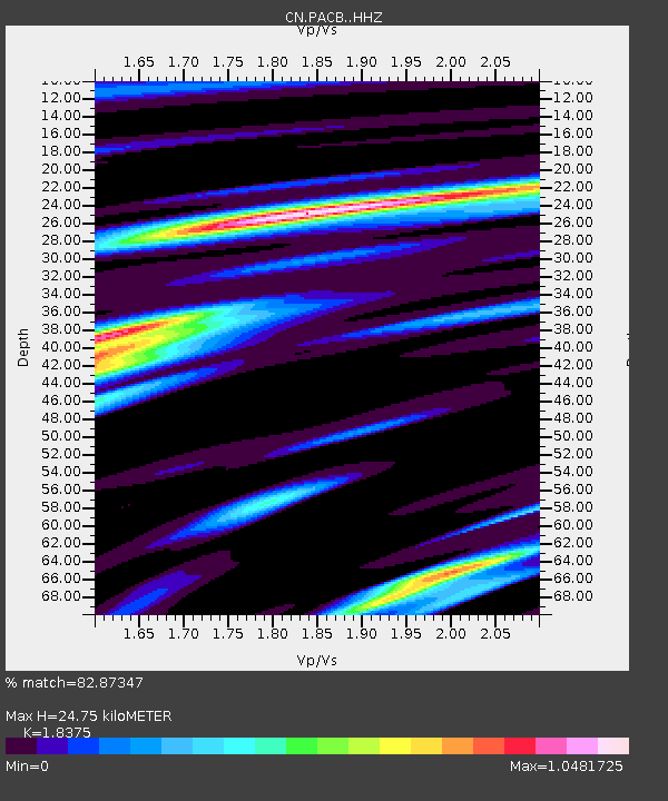
| Estimated Moho Depth: |
24.75 km |
| Estimated Crust Vp/Vs: |
1.84 |
| Assumed Crust Vp: |
6.545 km/s |
| Estimated Crust Vs: |
3.562 km/s |
| Estimated Crust Poisson's Ratio: |
0.29 |
|
| Radial Match: |
82.87347 % |
| Radial Bump: |
400 |
| Transverse Match: |
69.030624 % |
| Transverse Bump: |
400 |
| SOD ConfigId: |
30536071 |
| Insert Time: |
2023-07-24 20:53:04.857 +0000 |
| GWidth: |
2.5 |
| Max Bumps: |
400 |
| Tol: |
0.001 |
|

Signal To Noise
| Channel | StoN | STA | LTA |
| CN:PACB: :HHZ:20230710T20:38:00.220003Z | 3.3809443 | 3.1822654E-7 | 9.4123564E-8 |
| CN:PACB: :HHN:20230710T20:38:00.220003Z | 1.3374946 | 9.290754E-8 | 6.9463866E-8 |
| CN:PACB: :HHE:20230710T20:38:00.220003Z | 2.1330621 | 1.7530904E-7 | 8.218656E-8 |
| Arrivals |
| Ps | 3.3 SECOND |
| PpPs | 10 SECOND |
| PsPs/PpSs | 14 SECOND |


