You are here: Home > Network List > GT - Global Telemetered Seismograph Network (USAF/USGS) Stations List
> Station LPAZ La Paz , Bolivia > Earthquake Result Viewer
LPAZ La Paz , Bolivia - Earthquake Result Viewer

| Earthquake location: |
North Atlantic Ocean |
| Earthquake latitude/longitude: |
20.0/-61.1 |
| Earthquake time(UTC): |
2023/07/10 (191) 20:28:25 GMT |
| Earthquake Depth: |
10 km |
| Earthquake Magnitude: |
6.6 mww |
| Earthquake Catalog/Contributor: |
NEIC PDE/us |
|
| Network: |
GT Global Telemetered Seismograph Network (USAF/USGS) |
| Station: |
LPAZ La Paz , Bolivia |
| Lat/Lon: |
16.17 S/68.08 W |
| Elevation: |
4817 m |
|
| Distance: |
36.6 deg |
| Az: |
191.295 deg |
| Baz: |
11.05 deg |
| Ray Param: |
0.076615 |
| Estimated Moho Depth: |
44.75 km |
| Estimated Crust Vp/Vs: |
1.69 |
| Assumed Crust Vp: |
6.454 km/s |
| Estimated Crust Vs: |
3.83 km/s |
| Estimated Crust Poisson's Ratio: |
0.23 |
|
| Radial Match: |
86.23094 % |
| Radial Bump: |
400 |
| Transverse Match: |
71.89827 % |
| Transverse Bump: |
400 |
| SOD ConfigId: |
30536071 |
| Insert Time: |
2023-07-24 20:59:06.565 +0000 |
| GWidth: |
2.5 |
| Max Bumps: |
400 |
| Tol: |
0.001 |
|
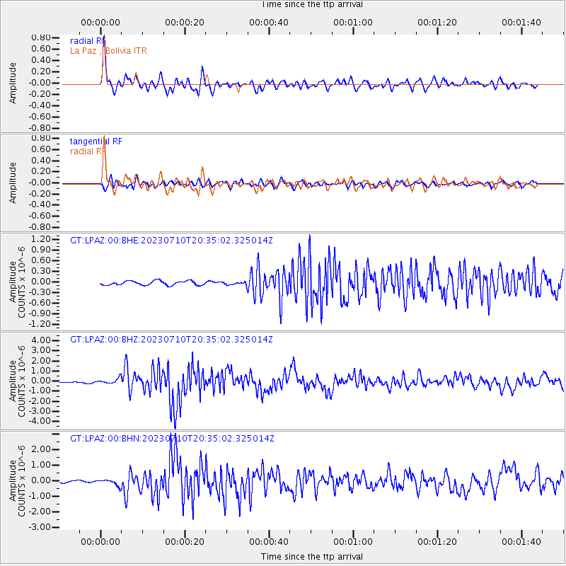
Signal To Noise
| Channel | StoN | STA | LTA |
| GT:LPAZ:00:BHZ:20230710T20:35:02.325014Z | 4.6177297 | 2.58432E-7 | 5.5965167E-8 |
| GT:LPAZ:00:BHN:20230710T20:35:02.325014Z | 2.2896252 | 1.9426767E-7 | 8.484693E-8 |
| GT:LPAZ:00:BHE:20230710T20:35:02.325014Z | 0.53693396 | 3.1818722E-8 | 5.9260024E-8 |
| Arrivals |
| Ps | 5.1 SECOND |
| PpPs | 17 SECOND |
| PsPs/PpSs | 22 SECOND |


