You are here: Home > Network List > IW - Intermountain West Stations List
> Station MOOW Moose Ponds, Wyoming, USA > Earthquake Result Viewer
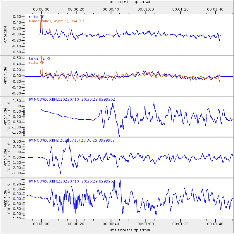
MOOW Moose Ponds, Wyoming, USA - Earthquake Result Viewer
*The percent match for this event was below the threshold and hence no stack was calculated.
| Earthquake location: |
North Atlantic Ocean |
| Earthquake latitude/longitude: |
20.0/-61.1 |
| Earthquake time(UTC): |
2023/07/10 (191) 20:28:25 GMT |
| Earthquake Depth: |
10 km |
| Earthquake Magnitude: |
6.6 mww |
| Earthquake Catalog/Contributor: |
NEIC PDE/us |
|
| Network: |
IW Intermountain West |
| Station: |
MOOW Moose Ponds, Wyoming, USA |
| Lat/Lon: |
43.75 N/110.74 W |
| Elevation: |
2128 m |
|
| Distance: |
47.5 deg |
| Az: |
311.479 deg |
| Baz: |
103.564 deg |
| Ray Param: |
$rayparam |
*The percent match for this event was below the threshold and hence was not used in the summary stack. |
|
| Radial Match: |
78.17329 % |
| Radial Bump: |
400 |
| Transverse Match: |
60.596577 % |
| Transverse Bump: |
400 |
| SOD ConfigId: |
30536071 |
| Insert Time: |
2023-07-24 21:01:48.584 +0000 |
| GWidth: |
2.5 |
| Max Bumps: |
400 |
| Tol: |
0.001 |
|
Signal To Noise
| Channel | StoN | STA | LTA |
| IW:MOOW:00:BHZ:20230710T20:36:29.899996Z | 16.179293 | 6.830144E-7 | 4.2215344E-8 |
| IW:MOOW:00:BH1:20230710T20:36:29.899996Z | 0.8028194 | 3.4999485E-7 | 4.3595713E-7 |
| IW:MOOW:00:BH2:20230710T20:36:29.899996Z | 1.1558346 | 3.348344E-7 | 2.896906E-7 |
| Arrivals |
| Ps | |
| PpPs | |
| PsPs/PpSs | |


