You are here: Home > Network List > IW - Intermountain West Stations List
> Station TPAW Teton Pass, Wyoming, USA > Earthquake Result Viewer
TPAW Teton Pass, Wyoming, USA - Earthquake Result Viewer
| Earthquake location: |
North Atlantic Ocean |
| Earthquake latitude/longitude: |
20.0/-61.1 |
| Earthquake time(UTC): |
2023/07/10 (191) 20:28:25 GMT |
| Earthquake Depth: |
10 km |
| Earthquake Magnitude: |
6.6 mww |
| Earthquake Catalog/Contributor: |
NEIC PDE/us |
|
| Network: |
IW Intermountain West |
| Station: |
TPAW Teton Pass, Wyoming, USA |
| Lat/Lon: |
43.49 N/110.95 W |
| Elevation: |
2512 m |
|
| Distance: |
47.6 deg |
| Az: |
311.091 deg |
| Baz: |
103.161 deg |
| Ray Param: |
0.0699095 |
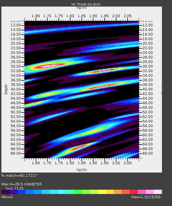
| Estimated Moho Depth: |
29.5 km |
| Estimated Crust Vp/Vs: |
1.71 |
| Assumed Crust Vp: |
6.207 km/s |
| Estimated Crust Vs: |
3.624 km/s |
| Estimated Crust Poisson's Ratio: |
0.24 |
|
| Radial Match: |
90.17227 % |
| Radial Bump: |
400 |
| Transverse Match: |
81.13619 % |
| Transverse Bump: |
400 |
| SOD ConfigId: |
30536071 |
| Insert Time: |
2023-07-24 21:01:58.775 +0000 |
| GWidth: |
2.5 |
| Max Bumps: |
400 |
| Tol: |
0.001 |
|

Signal To Noise
| Channel | StoN | STA | LTA |
| IW:TPAW:00:BHZ:20230710T20:36:30.599001Z | 14.636873 | 7.5827916E-7 | 5.180609E-8 |
| IW:TPAW:00:BH1:20230710T20:36:30.599001Z | 3.7602746 | 2.0895862E-7 | 5.5570045E-8 |
| IW:TPAW:00:BH2:20230710T20:36:30.599001Z | 4.1831045 | 3.8595977E-7 | 9.226635E-8 |
| Arrivals |
| Ps | 3.6 SECOND |
| PpPs | 12 SECOND |
| PsPs/PpSs | 16 SECOND |


