You are here: Home > Network List > MB - Montana Regional Seismic Network Stations List
> Station ECMT Emigrant Creek, MT > Earthquake Result Viewer
ECMT Emigrant Creek, MT - Earthquake Result Viewer
| Earthquake location: |
North Atlantic Ocean |
| Earthquake latitude/longitude: |
20.0/-61.1 |
| Earthquake time(UTC): |
2023/07/10 (191) 20:28:25 GMT |
| Earthquake Depth: |
10 km |
| Earthquake Magnitude: |
6.6 mww |
| Earthquake Catalog/Contributor: |
NEIC PDE/us |
|
| Network: |
MB Montana Regional Seismic Network |
| Station: |
ECMT Emigrant Creek, MT |
| Lat/Lon: |
45.32 N/110.74 W |
| Elevation: |
1567 m |
|
| Distance: |
47.9 deg |
| Az: |
313.541 deg |
| Baz: |
104.956 deg |
| Ray Param: |
0.06973202 |
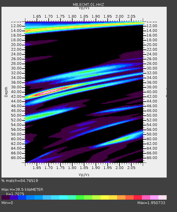
| Estimated Moho Depth: |
39.5 km |
| Estimated Crust Vp/Vs: |
1.71 |
| Assumed Crust Vp: |
6.35 km/s |
| Estimated Crust Vs: |
3.719 km/s |
| Estimated Crust Poisson's Ratio: |
0.24 |
|
| Radial Match: |
84.76519 % |
| Radial Bump: |
400 |
| Transverse Match: |
85.48387 % |
| Transverse Bump: |
400 |
| SOD ConfigId: |
30536071 |
| Insert Time: |
2023-07-24 21:02:37.981 +0000 |
| GWidth: |
2.5 |
| Max Bumps: |
400 |
| Tol: |
0.001 |
|

Signal To Noise
| Channel | StoN | STA | LTA |
| MB:ECMT:01:HHZ:20230710T20:36:32.869997Z | 10.09532 | 1.6600883E-6 | 1.6444137E-7 |
| MB:ECMT:01:HHN:20230710T20:36:32.869997Z | 1.4924294 | 3.5573166E-7 | 2.3835744E-7 |
| MB:ECMT:01:HHE:20230710T20:36:32.869997Z | 2.9295366 | 5.9745065E-7 | 2.0394033E-7 |
| Arrivals |
| Ps | 4.7 SECOND |
| PpPs | 16 SECOND |
| PsPs/PpSs | 21 SECOND |


