You are here: Home > Network List > GE - GEOFON Stations List
> Station EIL GEOFON Station Eilat, Israel > Earthquake Result Viewer
EIL GEOFON Station Eilat, Israel - Earthquake Result Viewer
| Earthquake location: |
Andaman Islands, India Region |
| Earthquake latitude/longitude: |
11.1/93.5 |
| Earthquake time(UTC): |
2010/05/31 (151) 19:51:45 GMT |
| Earthquake Depth: |
112 km |
| Earthquake Magnitude: |
6.1 MB, 6.5 MW, 6.4 MW |
| Earthquake Catalog/Contributor: |
WHDF/NEIC |
|
| Network: |
GE GEOFON |
| Station: |
EIL GEOFON Station Eilat, Israel |
| Lat/Lon: |
29.67 N/34.95 E |
| Elevation: |
210 m |
|
| Distance: |
57.3 deg |
| Az: |
298.091 deg |
| Baz: |
95.83 deg |
| Ray Param: |
0.06326068 |
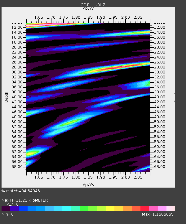
| Estimated Moho Depth: |
11.25 km |
| Estimated Crust Vp/Vs: |
1.60 |
| Assumed Crust Vp: |
6.472 km/s |
| Estimated Crust Vs: |
4.045 km/s |
| Estimated Crust Poisson's Ratio: |
0.18 |
|
| Radial Match: |
94.54945 % |
| Radial Bump: |
400 |
| Transverse Match: |
82.40011 % |
| Transverse Bump: |
400 |
| SOD ConfigId: |
317696 |
| Insert Time: |
2010-09-19 06:41:50.299 +0000 |
| GWidth: |
2.5 |
| Max Bumps: |
400 |
| Tol: |
0.001 |
|

Signal To Noise
| Channel | StoN | STA | LTA |
| GE:EIL: :BHZ:20100531T20:00:51.200017Z | 16.934446 | 9.120197E-7 | 5.3855892E-8 |
| GE:EIL: :BHN:20100531T20:00:51.200017Z | 2.116878 | 8.552438E-8 | 4.0401183E-8 |
| GE:EIL: :BHE:20100531T20:00:51.200017Z | 5.641593 | 3.4247597E-7 | 6.0705545E-8 |
| Arrivals |
| Ps | 1.1 SECOND |
| PpPs | 4.3 SECOND |
| PsPs/PpSs | 5.4 SECOND |


