You are here: Home > Network List > GT - Global Telemetered Seismograph Network (USAF/USGS) Stations List
> Station BOSA Boshof, South Africa > Earthquake Result Viewer
BOSA Boshof, South Africa - Earthquake Result Viewer
| Earthquake location: |
Andaman Islands, India Region |
| Earthquake latitude/longitude: |
11.1/93.5 |
| Earthquake time(UTC): |
2010/05/31 (151) 19:51:45 GMT |
| Earthquake Depth: |
112 km |
| Earthquake Magnitude: |
6.1 MB, 6.5 MW, 6.4 MW |
| Earthquake Catalog/Contributor: |
WHDF/NEIC |
|
| Network: |
GT Global Telemetered Seismograph Network (USAF/USGS) |
| Station: |
BOSA Boshof, South Africa |
| Lat/Lon: |
28.61 S/25.26 E |
| Elevation: |
1280 m |
|
| Distance: |
76.8 deg |
| Az: |
237.001 deg |
| Baz: |
69.42 deg |
| Ray Param: |
0.050509084 |
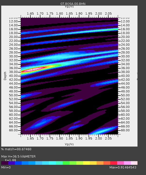
| Estimated Moho Depth: |
36.5 km |
| Estimated Crust Vp/Vs: |
1.66 |
| Assumed Crust Vp: |
6.459 km/s |
| Estimated Crust Vs: |
3.891 km/s |
| Estimated Crust Poisson's Ratio: |
0.22 |
|
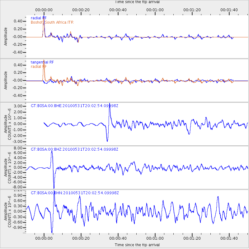
| Radial Match: |
88.67468 % |
| Radial Bump: |
252 |
| Transverse Match: |
67.005165 % |
| Transverse Bump: |
400 |
| SOD ConfigId: |
317696 |
| Insert Time: |
2010-09-19 06:42:05.835 +0000 |
| GWidth: |
2.5 |
| Max Bumps: |
400 |
| Tol: |
0.001 |
|
Signal To Noise
| Channel | StoN | STA | LTA |
| GT:BOSA:00:BHZ:20100531T20:02:54.09998Z | 6.6444044 | 2.513411E-6 | 3.7827482E-7 |
| GT:BOSA:00:BHN:20100531T20:02:54.09998Z | 2.4563406 | 4.4440554E-7 | 1.809218E-7 |
| GT:BOSA:00:BHE:20100531T20:02:54.09998Z | 5.589453 | 1.0529029E-6 | 1.8837315E-7 |
| Arrivals |
| Ps | 3.9 SECOND |
| PpPs | 15 SECOND |
| PsPs/PpSs | 18 SECOND |


