You are here: Home > Network List > NM - Cooperative New Madrid Seismic Network Stations List
> Station PARM Stahl Farm,MO > Earthquake Result Viewer
PARM Stahl Farm,MO - Earthquake Result Viewer
| Earthquake location: |
North Atlantic Ocean |
| Earthquake latitude/longitude: |
20.0/-61.1 |
| Earthquake time(UTC): |
2023/07/10 (191) 20:28:25 GMT |
| Earthquake Depth: |
10 km |
| Earthquake Magnitude: |
6.6 mww |
| Earthquake Catalog/Contributor: |
NEIC PDE/us |
|
| Network: |
NM Cooperative New Madrid Seismic Network |
| Station: |
PARM Stahl Farm,MO |
| Lat/Lon: |
36.66 N/89.75 W |
| Elevation: |
85 m |
|
| Distance: |
30.0 deg |
| Az: |
309.595 deg |
| Baz: |
115.692 deg |
| Ray Param: |
0.07953401 |
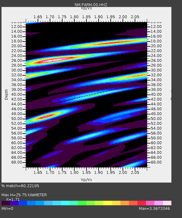
| Estimated Moho Depth: |
25.75 km |
| Estimated Crust Vp/Vs: |
1.71 |
| Assumed Crust Vp: |
6.444 km/s |
| Estimated Crust Vs: |
3.768 km/s |
| Estimated Crust Poisson's Ratio: |
0.24 |
|
| Radial Match: |
90.22185 % |
| Radial Bump: |
318 |
| Transverse Match: |
67.02434 % |
| Transverse Bump: |
400 |
| SOD ConfigId: |
30536071 |
| Insert Time: |
2023-07-24 21:04:55.302 +0000 |
| GWidth: |
2.5 |
| Max Bumps: |
400 |
| Tol: |
0.001 |
|

Signal To Noise
| Channel | StoN | STA | LTA |
| NM:PARM:00:HHZ:20230710T20:34:04.04999Z | 24.230434 | 3.2638468E-6 | 1.347003E-7 |
| NM:PARM:00:HHN:20230710T20:34:04.04999Z | 3.5322068 | 1.1151307E-6 | 3.1570366E-7 |
| NM:PARM:00:HHE:20230710T20:34:04.04999Z | 9.744979 | 2.211183E-6 | 2.2690487E-7 |
| Arrivals |
| Ps | 3.1 SECOND |
| PpPs | 10.0 SECOND |
| PsPs/PpSs | 13 SECOND |


