You are here: Home > Network List > TA - USArray Transportable Network (new EarthScope stations) Stations List
> Station TOLK Toolik Lake Research Station, AK, USA > Earthquake Result Viewer
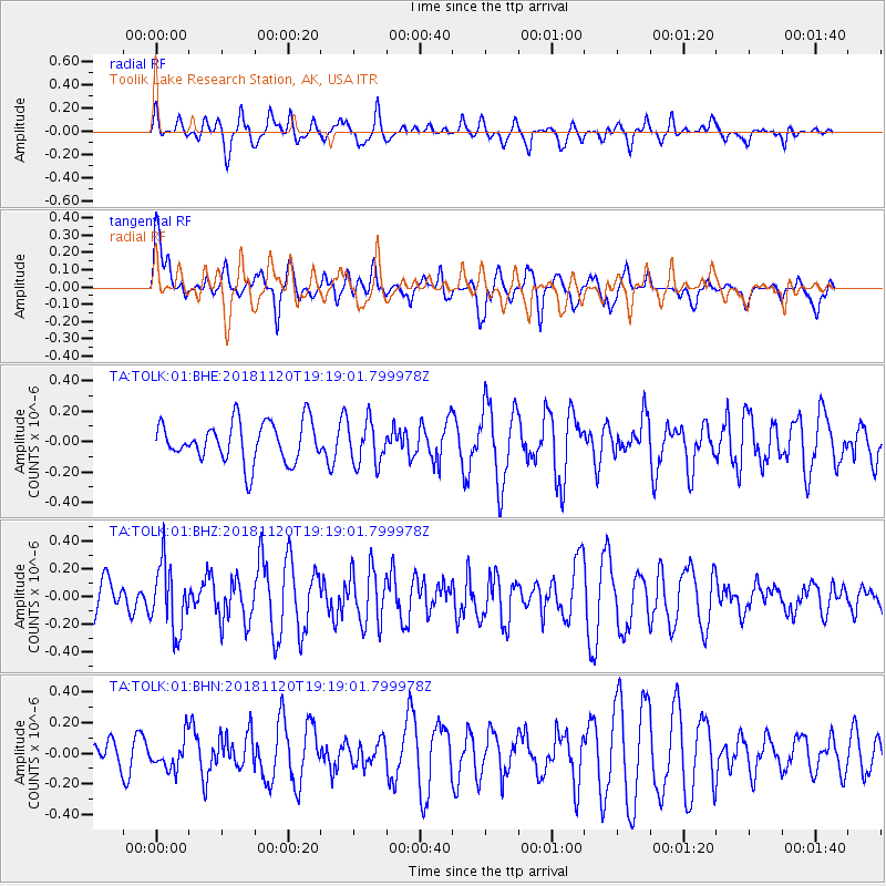
TOLK Toolik Lake Research Station, AK, USA - Earthquake Result Viewer
*The percent match for this event was below the threshold and hence no stack was calculated.
| Earthquake location: |
Kyushu, Japan |
| Earthquake latitude/longitude: |
30.4/130.1 |
| Earthquake time(UTC): |
2018/11/20 (324) 19:09:48 GMT |
| Earthquake Depth: |
123 km |
| Earthquake Magnitude: |
5.5 Mww |
| Earthquake Catalog/Contributor: |
NEIC PDE/us |
|
| Network: |
TA USArray Transportable Network (new EarthScope stations) |
| Station: |
TOLK Toolik Lake Research Station, AK, USA |
| Lat/Lon: |
68.64 N/149.57 W |
| Elevation: |
760 m |
|
| Distance: |
58.6 deg |
| Az: |
25.044 deg |
| Baz: |
273.351 deg |
| Ray Param: |
$rayparam |
*The percent match for this event was below the threshold and hence was not used in the summary stack. |
|
| Radial Match: |
53.171497 % |
| Radial Bump: |
400 |
| Transverse Match: |
51.068016 % |
| Transverse Bump: |
400 |
| SOD ConfigId: |
3165032 |
| Insert Time: |
2018-12-04 19:19:27.396 +0000 |
| GWidth: |
2.5 |
| Max Bumps: |
400 |
| Tol: |
0.001 |
|
Signal To Noise
| Channel | StoN | STA | LTA |
| TA:TOLK:01:BHZ:20181120T19:19:01.799978Z | 2.1692483 | 2.3728322E-7 | 1.09385E-7 |
| TA:TOLK:01:BHN:20181120T19:19:01.799978Z | 0.89113253 | 1.0139397E-7 | 1.1378103E-7 |
| TA:TOLK:01:BHE:20181120T19:19:01.799978Z | 1.0878465 | 1.4186914E-7 | 1.3041281E-7 |
| Arrivals |
| Ps | |
| PpPs | |
| PsPs/PpSs | |


