You are here: Home > Network List > NX - Nanometrics Research Network Stations List
> Station WTX29 Z > Earthquake Result Viewer
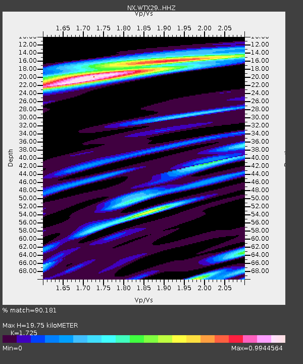
WTX29 Z - Earthquake Result Viewer
| Earthquake location: |
North Atlantic Ocean |
| Earthquake latitude/longitude: |
20.0/-61.1 |
| Earthquake time(UTC): |
2023/07/10 (191) 20:28:25 GMT |
| Earthquake Depth: |
10 km |
| Earthquake Magnitude: |
6.6 mww |
| Earthquake Catalog/Contributor: |
NEIC PDE/us |
|
| Network: |
NX Nanometrics Research Network |
| Station: |
WTX29 Z |
| Lat/Lon: |
32.74 N/103.56 W |
| Elevation: |
1207 m |
|
| Distance: |
39.8 deg |
| Az: |
297.372 deg |
| Baz: |
97.768 deg |
| Ray Param: |
0.07474777 |
| Estimated Moho Depth: |
19.75 km |
| Estimated Crust Vp/Vs: |
1.73 |
| Assumed Crust Vp: |
6.129 km/s |
| Estimated Crust Vs: |
3.553 km/s |
| Estimated Crust Poisson's Ratio: |
0.25 |
|
| Radial Match: |
90.181 % |
| Radial Bump: |
333 |
| Transverse Match: |
61.649544 % |
| Transverse Bump: |
400 |
| SOD ConfigId: |
30536071 |
| Insert Time: |
2023-07-24 21:06:55.790 +0000 |
| GWidth: |
2.5 |
| Max Bumps: |
400 |
| Tol: |
0.001 |
|

Signal To Noise
| Channel | StoN | STA | LTA |
| NX:WTX29: :HHZ:20230710T20:35:28.41501Z | 20.733513 | 1.7388546E-6 | 8.386686E-8 |
| NX:WTX29: :HHN:20230710T20:35:28.41501Z | 2.0856924 | 8.387633E-7 | 4.02151E-7 |
| NX:WTX29: :HHE:20230710T20:35:28.41501Z | 2.9390817 | 1.3169124E-6 | 4.4806936E-7 |
| Arrivals |
| Ps | 2.5 SECOND |
| PpPs | 8.2 SECOND |
| PsPs/PpSs | 11 SECOND |


