You are here: Home > Network List > O2 - Oklahoma Consolidated Temporary Seismic Networks Stations List
> Station CALT Calumet, Oklahoma, USA > Earthquake Result Viewer
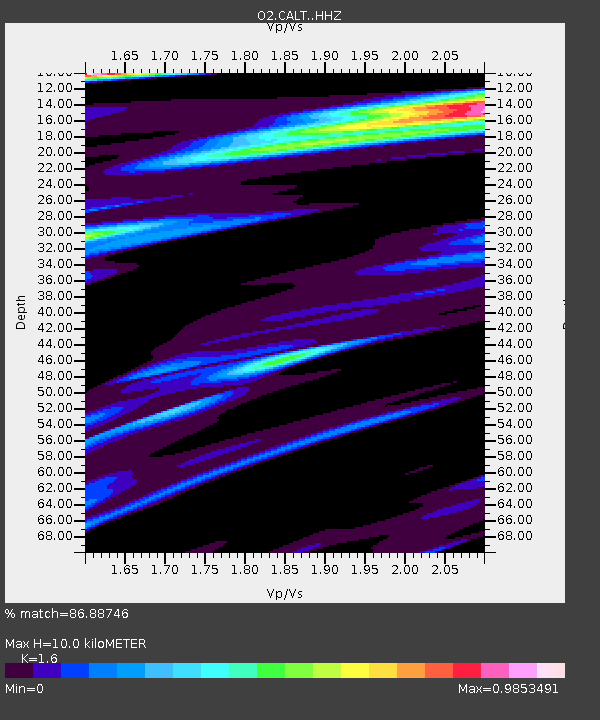
CALT Calumet, Oklahoma, USA - Earthquake Result Viewer
| Earthquake location: |
North Atlantic Ocean |
| Earthquake latitude/longitude: |
20.0/-61.1 |
| Earthquake time(UTC): |
2023/07/10 (191) 20:28:25 GMT |
| Earthquake Depth: |
10 km |
| Earthquake Magnitude: |
6.6 mww |
| Earthquake Catalog/Contributor: |
NEIC PDE/us |
|
| Network: |
O2 Oklahoma Consolidated Temporary Seismic Networks |
| Station: |
CALT Calumet, Oklahoma, USA |
| Lat/Lon: |
35.67 N/98.22 W |
| Elevation: |
430 m |
|
| Distance: |
36.1 deg |
| Az: |
303.476 deg |
| Baz: |
105.573 deg |
| Ray Param: |
0.076891884 |
| Estimated Moho Depth: |
10.0 km |
| Estimated Crust Vp/Vs: |
1.60 |
| Assumed Crust Vp: |
6.315 km/s |
| Estimated Crust Vs: |
3.947 km/s |
| Estimated Crust Poisson's Ratio: |
0.18 |
|
| Radial Match: |
86.88746 % |
| Radial Bump: |
371 |
| Transverse Match: |
55.858227 % |
| Transverse Bump: |
400 |
| SOD ConfigId: |
30536071 |
| Insert Time: |
2023-07-24 21:07:12.843 +0000 |
| GWidth: |
2.5 |
| Max Bumps: |
400 |
| Tol: |
0.001 |
|

Signal To Noise
| Channel | StoN | STA | LTA |
| O2:CALT: :HHZ:20230710T20:34:56.864992Z | 23.416803 | 1.5913903E-6 | 6.795933E-8 |
| O2:CALT: :HHN:20230710T20:34:56.864992Z | 1.3291223 | 1.7207086E-7 | 1.2946202E-7 |
| O2:CALT: :HHE:20230710T20:34:56.864992Z | 3.3481274 | 8.7440554E-7 | 2.6116257E-7 |
| Arrivals |
| Ps | 1.0 SECOND |
| PpPs | 3.8 SECOND |
| PsPs/PpSs | 4.8 SECOND |


