You are here: Home > Network List > O2 - Oklahoma Consolidated Temporary Seismic Networks Stations List
> Station ERNS El Reno, Oklahoma, USA > Earthquake Result Viewer
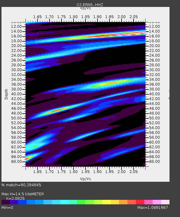
ERNS El Reno, Oklahoma, USA - Earthquake Result Viewer
| Earthquake location: |
North Atlantic Ocean |
| Earthquake latitude/longitude: |
20.0/-61.1 |
| Earthquake time(UTC): |
2023/07/10 (191) 20:28:25 GMT |
| Earthquake Depth: |
10 km |
| Earthquake Magnitude: |
6.6 mww |
| Earthquake Catalog/Contributor: |
NEIC PDE/us |
|
| Network: |
O2 Oklahoma Consolidated Temporary Seismic Networks |
| Station: |
ERNS El Reno, Oklahoma, USA |
| Lat/Lon: |
35.42 N/98.03 W |
| Elevation: |
418 m |
|
| Distance: |
35.9 deg |
| Az: |
303.142 deg |
| Baz: |
105.413 deg |
| Ray Param: |
0.07699889 |
| Estimated Moho Depth: |
14.5 km |
| Estimated Crust Vp/Vs: |
2.08 |
| Assumed Crust Vp: |
6.315 km/s |
| Estimated Crust Vs: |
3.033 km/s |
| Estimated Crust Poisson's Ratio: |
0.35 |
|
| Radial Match: |
90.294945 % |
| Radial Bump: |
286 |
| Transverse Match: |
62.98389 % |
| Transverse Bump: |
400 |
| SOD ConfigId: |
30536071 |
| Insert Time: |
2023-07-24 21:07:30.269 +0000 |
| GWidth: |
2.5 |
| Max Bumps: |
400 |
| Tol: |
0.001 |
|

Signal To Noise
| Channel | StoN | STA | LTA |
| O2:ERNS: :HHZ:20230710T20:34:55.019991Z | 12.520498 | 1.8924397E-6 | 1.5114732E-7 |
| O2:ERNS: :HHN:20230710T20:34:55.019991Z | 1.6627257 | 3.1572358E-7 | 1.8988315E-7 |
| O2:ERNS: :HHE:20230710T20:34:55.019991Z | 7.8742523 | 9.099942E-7 | 1.1556579E-7 |
| Arrivals |
| Ps | 2.6 SECOND |
| PpPs | 6.7 SECOND |
| PsPs/PpSs | 9.3 SECOND |


