You are here: Home > Network List > II - Global Seismograph Network (GSN - IRIS/IDA) Stations List
> Station WRAB Tennant Creek, NT, Australia > Earthquake Result Viewer
WRAB Tennant Creek, NT, Australia - Earthquake Result Viewer
| Earthquake location: |
Andaman Islands, India Region |
| Earthquake latitude/longitude: |
11.1/93.5 |
| Earthquake time(UTC): |
2010/05/31 (151) 19:51:45 GMT |
| Earthquake Depth: |
112 km |
| Earthquake Magnitude: |
6.1 MB, 6.5 MW, 6.4 MW |
| Earthquake Catalog/Contributor: |
WHDF/NEIC |
|
| Network: |
II Global Seismograph Network (GSN - IRIS/IDA) |
| Station: |
WRAB Tennant Creek, NT, Australia |
| Lat/Lon: |
19.93 S/134.36 E |
| Elevation: |
366 m |
|
| Distance: |
50.7 deg |
| Az: |
127.294 deg |
| Baz: |
303.914 deg |
| Ray Param: |
0.067505434 |
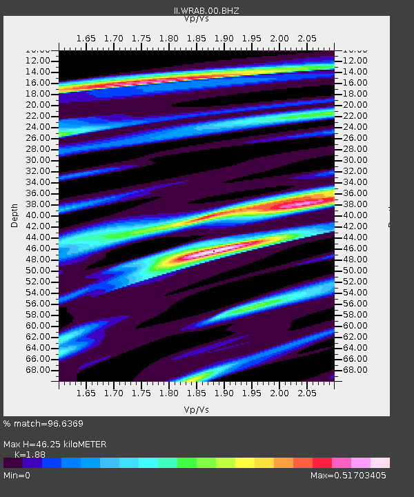
| Estimated Moho Depth: |
46.25 km |
| Estimated Crust Vp/Vs: |
1.88 |
| Assumed Crust Vp: |
6.642 km/s |
| Estimated Crust Vs: |
3.533 km/s |
| Estimated Crust Poisson's Ratio: |
0.30 |
|
| Radial Match: |
96.6369 % |
| Radial Bump: |
228 |
| Transverse Match: |
75.58683 % |
| Transverse Bump: |
400 |
| SOD ConfigId: |
317696 |
| Insert Time: |
2010-09-19 06:42:33.532 +0000 |
| GWidth: |
2.5 |
| Max Bumps: |
400 |
| Tol: |
0.001 |
|
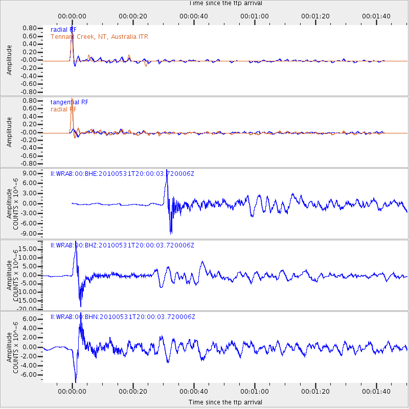
Signal To Noise
| Channel | StoN | STA | LTA |
| II:WRAB:00:BHZ:20100531T20:00:03.720006Z | 36.25722 | 8.544492E-6 | 2.3566318E-7 |
| II:WRAB:00:BHN:20100531T20:00:03.720006Z | 11.966657 | 3.3383149E-6 | 2.7896803E-7 |
| II:WRAB:00:BHE:20100531T20:00:03.720006Z | 23.010187 | 4.1019143E-6 | 1.7826514E-7 |
| Arrivals |
| Ps | 6.5 SECOND |
| PpPs | 19 SECOND |
| PsPs/PpSs | 25 SECOND |


