You are here: Home > Network List > O2 - Oklahoma Consolidated Temporary Seismic Networks Stations List
> Station PW18 Morrison, Oklahoma, USA > Earthquake Result Viewer
PW18 Morrison, Oklahoma, USA - Earthquake Result Viewer
| Earthquake location: |
North Atlantic Ocean |
| Earthquake latitude/longitude: |
20.0/-61.1 |
| Earthquake time(UTC): |
2023/07/10 (191) 20:28:25 GMT |
| Earthquake Depth: |
10 km |
| Earthquake Magnitude: |
6.6 mww |
| Earthquake Catalog/Contributor: |
NEIC PDE/us |
|
| Network: |
O2 Oklahoma Consolidated Temporary Seismic Networks |
| Station: |
PW18 Morrison, Oklahoma, USA |
| Lat/Lon: |
36.28 N/97.04 W |
| Elevation: |
299 m |
|
| Distance: |
35.4 deg |
| Az: |
304.935 deg |
| Baz: |
107.446 deg |
| Ray Param: |
0.07726867 |
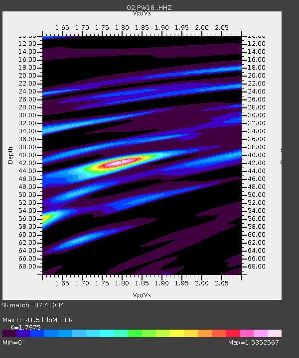
| Estimated Moho Depth: |
41.5 km |
| Estimated Crust Vp/Vs: |
1.80 |
| Assumed Crust Vp: |
6.483 km/s |
| Estimated Crust Vs: |
3.606 km/s |
| Estimated Crust Poisson's Ratio: |
0.28 |
|
| Radial Match: |
87.41034 % |
| Radial Bump: |
271 |
| Transverse Match: |
59.84218 % |
| Transverse Bump: |
400 |
| SOD ConfigId: |
30536071 |
| Insert Time: |
2023-07-24 21:08:18.779 +0000 |
| GWidth: |
2.5 |
| Max Bumps: |
400 |
| Tol: |
0.001 |
|

Signal To Noise
| Channel | StoN | STA | LTA |
| O2:PW18: :HHZ:20230710T20:34:50.505007Z | 26.21594 | 2.0977777E-6 | 8.001916E-8 |
| O2:PW18: :HHN:20230710T20:34:50.505007Z | 1.4149027 | 3.8396996E-7 | 2.7137554E-7 |
| O2:PW18: :HHE:20230710T20:34:50.505007Z | 9.010137 | 1.1981712E-6 | 1.3298035E-7 |
| Arrivals |
| Ps | 5.5 SECOND |
| PpPs | 17 SECOND |
| PsPs/PpSs | 22 SECOND |


