You are here: Home > Network List > O2 - Oklahoma Consolidated Temporary Seismic Networks Stations List
> Station SC14 Walters, Oklahoma, USA > Earthquake Result Viewer
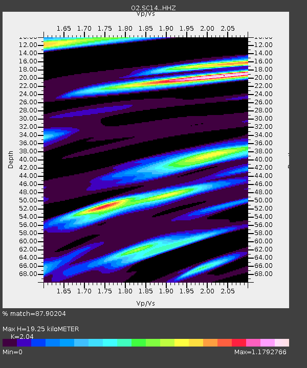
SC14 Walters, Oklahoma, USA - Earthquake Result Viewer
| Earthquake location: |
North Atlantic Ocean |
| Earthquake latitude/longitude: |
20.0/-61.1 |
| Earthquake time(UTC): |
2023/07/10 (191) 20:28:25 GMT |
| Earthquake Depth: |
10 km |
| Earthquake Magnitude: |
6.6 mww |
| Earthquake Catalog/Contributor: |
NEIC PDE/us |
|
| Network: |
O2 Oklahoma Consolidated Temporary Seismic Networks |
| Station: |
SC14 Walters, Oklahoma, USA |
| Lat/Lon: |
34.45 N/98.24 W |
| Elevation: |
339 m |
|
| Distance: |
35.8 deg |
| Az: |
301.463 deg |
| Baz: |
103.93 deg |
| Ray Param: |
0.077031866 |
| Estimated Moho Depth: |
19.25 km |
| Estimated Crust Vp/Vs: |
2.04 |
| Assumed Crust Vp: |
6.315 km/s |
| Estimated Crust Vs: |
3.096 km/s |
| Estimated Crust Poisson's Ratio: |
0.34 |
|
| Radial Match: |
87.90204 % |
| Radial Bump: |
355 |
| Transverse Match: |
61.003277 % |
| Transverse Bump: |
400 |
| SOD ConfigId: |
30536071 |
| Insert Time: |
2023-07-24 21:09:01.177 +0000 |
| GWidth: |
2.5 |
| Max Bumps: |
400 |
| Tol: |
0.001 |
|

Signal To Noise
| Channel | StoN | STA | LTA |
| O2:SC14: :HHZ:20230710T20:34:54.375002Z | 25.054466 | 2.4871922E-6 | 9.927141E-8 |
| O2:SC14: :HHN:20230710T20:34:54.375002Z | 3.8648212 | 3.0039516E-7 | 7.7725495E-8 |
| O2:SC14: :HHE:20230710T20:34:54.375002Z | 10.661239 | 1.2062578E-6 | 1.13144246E-7 |
| Arrivals |
| Ps | 3.4 SECOND |
| PpPs | 8.7 SECOND |
| PsPs/PpSs | 12 SECOND |


